You are here: Home > Network List > II - Global Seismograph Network (GSN - IRIS/IDA) Stations List
> Station PALK Pallekele, Sri Lanka > Earthquake Result Viewer
PALK Pallekele, Sri Lanka - Earthquake Result Viewer
| Earthquake location: |
Mindanao, Philippines |
| Earthquake latitude/longitude: |
5.6/125.0 |
| Earthquake time(UTC): |
2023/11/17 (321) 08:14:11 GMT |
| Earthquake Depth: |
64 km |
| Earthquake Magnitude: |
6.7 Mww |
| Earthquake Catalog/Contributor: |
NEIC PDE/us |
|
| Network: |
II Global Seismograph Network (GSN - IRIS/IDA) |
| Station: |
PALK Pallekele, Sri Lanka |
| Lat/Lon: |
7.27 N/80.70 E |
| Elevation: |
460 m |
|
| Distance: |
44.1 deg |
| Az: |
274.666 deg |
| Baz: |
89.479 deg |
| Ray Param: |
0.07197918 |
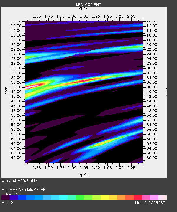
| Estimated Moho Depth: |
37.75 km |
| Estimated Crust Vp/Vs: |
1.62 |
| Assumed Crust Vp: |
6.545 km/s |
| Estimated Crust Vs: |
4.04 km/s |
| Estimated Crust Poisson's Ratio: |
0.19 |
|
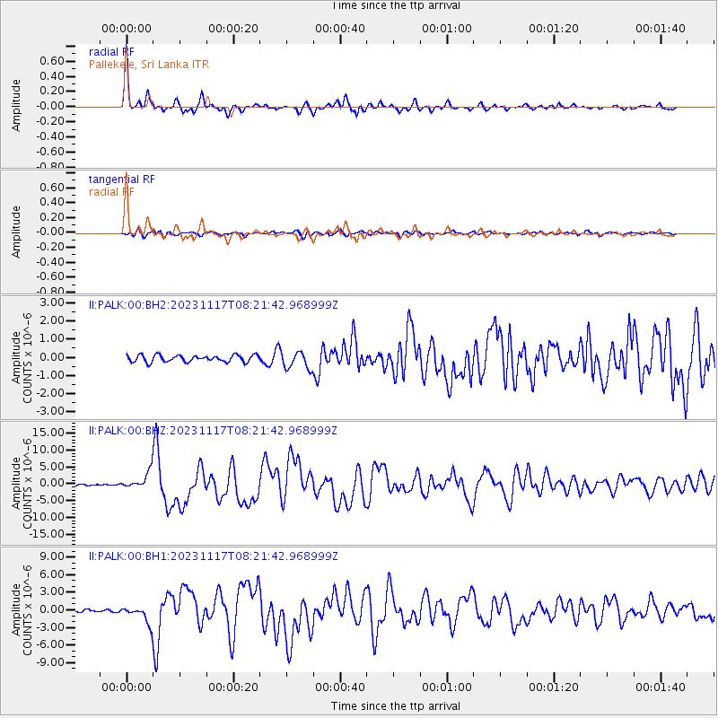
| Radial Match: |
95.84914 % |
| Radial Bump: |
304 |
| Transverse Match: |
77.44387 % |
| Transverse Bump: |
400 |
| SOD ConfigId: |
31937991 |
| Insert Time: |
2023-12-01 08:28:09.417 +0000 |
| GWidth: |
2.5 |
| Max Bumps: |
400 |
| Tol: |
0.001 |
|
Signal To Noise
| Channel | StoN | STA | LTA |
| II:PALK:00:BHZ:20231117T08:21:42.968999Z | 9.198184 | 2.5682004E-6 | 2.7920734E-7 |
| II:PALK:00:BH1:20231117T08:21:42.968999Z | 7.06676 | 1.4849833E-6 | 2.1013636E-7 |
| II:PALK:00:BH2:20231117T08:21:42.968999Z | 2.605437 | 4.7643738E-7 | 1.8286275E-7 |
| Arrivals |
| Ps | 3.9 SECOND |
| PpPs | 14 SECOND |
| PsPs/PpSs | 18 SECOND |


