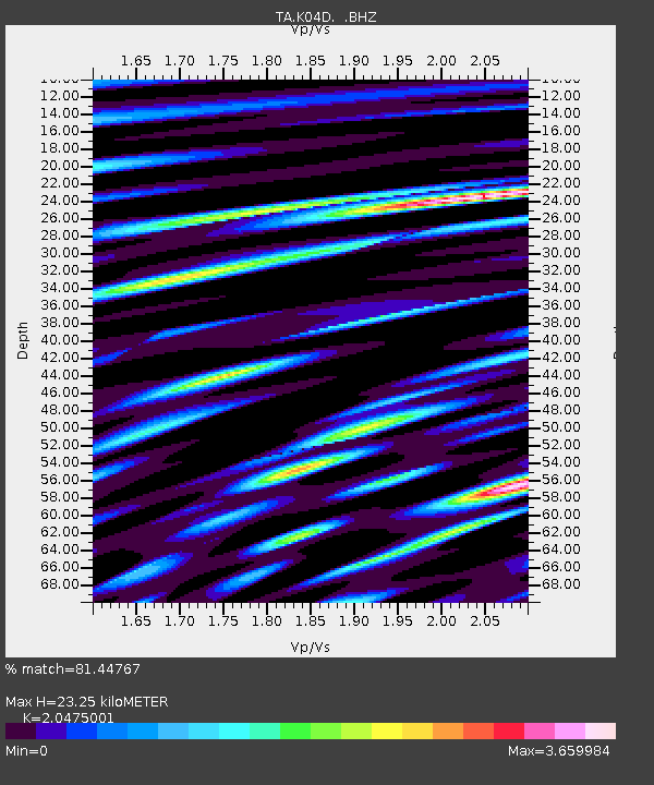
K04D Chiloquin, OR, USA - Earthquake Result Viewer

Earthquake location: Andreanof Islands, Aleutian Is.
Earthquake latitude/longitude: 51.3/-178.6
Earthquake time(UTC): 2010/08/08 (220) 12:04:28 GMT
Earthquake Depth: 29 km
Earthquake Magnitude: 5.7 MB, 5.0 MS, 5.4 MW, 5.8 ML
Earthquake Catalog/Contributor: WHDF/NEIC
Network: TA USArray Transportable Network (new EarthScope stations)
Station: K04D Chiloquin, OR, USA
Lat/Lon: 42.62 N/121.75 W
Elevation: 1315 m
Distance: 38.8 deg
Az: 80.012 deg
Baz: 303.143 deg
Ray Param: 0.07527853
Estimated Moho Depth: 23.25 km
Estimated Crust Vp/Vs: 2.05
Assumed Crust Vp: 6.597 km/s
Estimated Crust Vs: 3.222 km/s
Estimated Crust Poisson's Ratio: 0.34
Radial Match: 81.44767 %
Radial Bump: 400
Transverse Match: 76.18388 %
Transverse Bump: 400
SOD ConfigId: 319893
Insert Time: 2011-01-05 18:52:39.608 +0000
GWidth: 2.5
Max Bumps: 400
Tol: 0.001

Signal To Noise

ChannelStoNSTALTA
TA:K04D: :BHZ:20100808T12:11:20.800005Z12.3540491.3215374E-61.0697201E-7
TA:K04D: :BHN:20100808T12:11:20.800005Z2.7383974.8473873E-71.7701552E-7
TA:K04D: :BHE:20100808T12:11:20.800005Z4.44209347.7932805E-71.754416E-7
Arrivals
Ps3.9 SECOND
PpPs10 SECOND
PsPs/PpSs14 SECOND