You are here: Home > Network List > MM - Myanmar National Seismic Network Stations List
> Station NGU Ngaung U, Myanmar > Earthquake Result Viewer
NGU Ngaung U, Myanmar - Earthquake Result Viewer
| Earthquake location: |
Mindanao, Philippines |
| Earthquake latitude/longitude: |
5.6/125.0 |
| Earthquake time(UTC): |
2023/11/17 (321) 08:14:11 GMT |
| Earthquake Depth: |
64 km |
| Earthquake Magnitude: |
6.7 Mww |
| Earthquake Catalog/Contributor: |
NEIC PDE/us |
|
| Network: |
MM Myanmar National Seismic Network |
| Station: |
NGU Ngaung U, Myanmar |
| Lat/Lon: |
21.21 N/94.92 E |
| Elevation: |
70 m |
|
| Distance: |
33.0 deg |
| Az: |
300.882 deg |
| Baz: |
113.73 deg |
| Ray Param: |
0.07824348 |
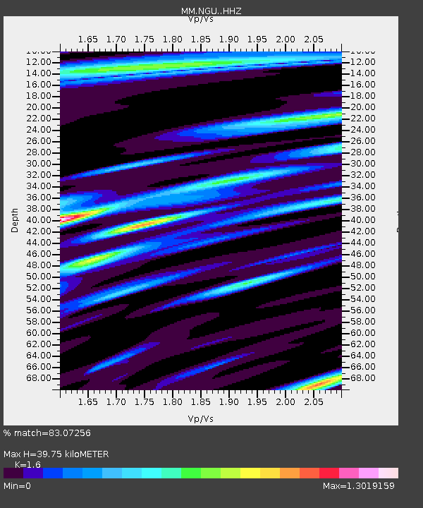
| Estimated Moho Depth: |
39.75 km |
| Estimated Crust Vp/Vs: |
1.60 |
| Assumed Crust Vp: |
6.036 km/s |
| Estimated Crust Vs: |
3.773 km/s |
| Estimated Crust Poisson's Ratio: |
0.18 |
|
| Radial Match: |
83.07256 % |
| Radial Bump: |
388 |
| Transverse Match: |
75.65026 % |
| Transverse Bump: |
347 |
| SOD ConfigId: |
31937991 |
| Insert Time: |
2023-12-01 08:30:06.285 +0000 |
| GWidth: |
2.5 |
| Max Bumps: |
400 |
| Tol: |
0.001 |
|

Signal To Noise
| Channel | StoN | STA | LTA |
| MM:NGU: :HHZ:20231117T08:20:10.949987Z | 32.167545 | 1.197149E-5 | 3.721605E-7 |
| MM:NGU: :HHN:20231117T08:20:10.949987Z | 4.467684 | 1.7367246E-6 | 3.8873043E-7 |
| MM:NGU: :HHE:20231117T08:20:10.949987Z | 9.016168 | 3.2372816E-6 | 3.5905296E-7 |
| Arrivals |
| Ps | 4.3 SECOND |
| PpPs | 16 SECOND |
| PsPs/PpSs | 20 SECOND |


