You are here: Home > Network List > PQ - Public Safety Geoscience Program Canadian Research Network (PSGP) Stations List
> Station TSIIG Tsiigehtchic, Northwest Territory > Earthquake Result Viewer
TSIIG Tsiigehtchic, Northwest Territory - Earthquake Result Viewer
| Earthquake location: |
Mindanao, Philippines |
| Earthquake latitude/longitude: |
5.6/125.0 |
| Earthquake time(UTC): |
2023/11/17 (321) 08:14:11 GMT |
| Earthquake Depth: |
64 km |
| Earthquake Magnitude: |
6.7 Mww |
| Earthquake Catalog/Contributor: |
NEIC PDE/us |
|
| Network: |
PQ Public Safety Geoscience Program Canadian Research Network (PSGP) |
| Station: |
TSIIG Tsiigehtchic, Northwest Territory |
| Lat/Lon: |
67.44 N/133.74 W |
| Elevation: |
56 m |
|
| Distance: |
89.2 deg |
| Az: |
22.24 deg |
| Baz: |
282.488 deg |
| Ray Param: |
0.041929368 |
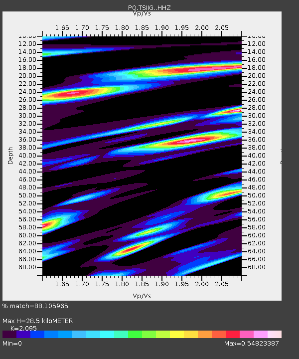
| Estimated Moho Depth: |
28.5 km |
| Estimated Crust Vp/Vs: |
2.10 |
| Assumed Crust Vp: |
6.171 km/s |
| Estimated Crust Vs: |
2.946 km/s |
| Estimated Crust Poisson's Ratio: |
0.35 |
|
| Radial Match: |
88.105965 % |
| Radial Bump: |
400 |
| Transverse Match: |
82.12698 % |
| Transverse Bump: |
400 |
| SOD ConfigId: |
31937991 |
| Insert Time: |
2023-12-01 08:31:01.426 +0000 |
| GWidth: |
2.5 |
| Max Bumps: |
400 |
| Tol: |
0.001 |
|

Signal To Noise
| Channel | StoN | STA | LTA |
| PQ:TSIIG: :HHZ:20231117T08:26:29.299993Z | 44.157726 | 5.421087E-6 | 1.2276644E-7 |
| PQ:TSIIG: :HHN:20231117T08:26:29.299993Z | 6.3006725 | 7.5781713E-7 | 1.2027559E-7 |
| PQ:TSIIG: :HHE:20231117T08:26:29.299993Z | 14.806233 | 1.610124E-6 | 1.08746356E-7 |
| Arrivals |
| Ps | 5.1 SECOND |
| PpPs | 14 SECOND |
| PsPs/PpSs | 19 SECOND |


