You are here: Home > Network List > TA - USArray Transportable Network (new EarthScope stations) Stations List
> Station 135A Vickery Place, Crowley, TX, USA > Earthquake Result Viewer
135A Vickery Place, Crowley, TX, USA - Earthquake Result Viewer
| Earthquake location: |
Andreanof Islands, Aleutian Is. |
| Earthquake latitude/longitude: |
51.3/-178.6 |
| Earthquake time(UTC): |
2010/08/08 (220) 12:04:28 GMT |
| Earthquake Depth: |
29 km |
| Earthquake Magnitude: |
5.7 MB, 5.0 MS, 5.4 MW, 5.8 ML |
| Earthquake Catalog/Contributor: |
WHDF/NEIC |
|
| Network: |
TA USArray Transportable Network (new EarthScope stations) |
| Station: |
135A Vickery Place, Crowley, TX, USA |
| Lat/Lon: |
32.56 N/97.41 W |
| Elevation: |
270 m |
|
| Distance: |
60.1 deg |
| Az: |
74.277 deg |
| Baz: |
314.336 deg |
| Ray Param: |
0.06171141 |
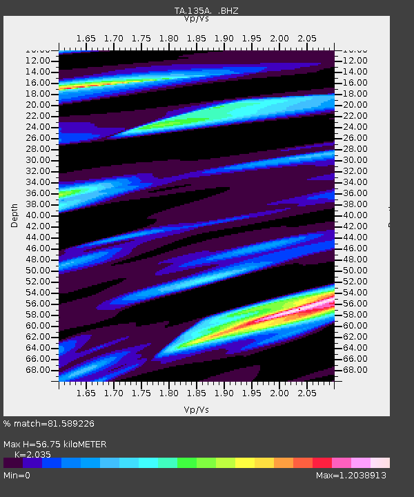
| Estimated Moho Depth: |
56.75 km |
| Estimated Crust Vp/Vs: |
2.04 |
| Assumed Crust Vp: |
6.38 km/s |
| Estimated Crust Vs: |
3.135 km/s |
| Estimated Crust Poisson's Ratio: |
0.34 |
|
| Radial Match: |
81.589226 % |
| Radial Bump: |
400 |
| Transverse Match: |
55.447998 % |
| Transverse Bump: |
400 |
| SOD ConfigId: |
319893 |
| Insert Time: |
2011-01-05 18:55:52.889 +0000 |
| GWidth: |
2.5 |
| Max Bumps: |
400 |
| Tol: |
0.001 |
|

Signal To Noise
| Channel | StoN | STA | LTA |
| TA:135A: :BHZ:20100808T12:14:02.575029Z | 6.5523205 | 9.979257E-7 | 1.523011E-7 |
| TA:135A: :BHN:20100808T12:14:02.575029Z | 2.9715526 | 3.467652E-7 | 1.1669496E-7 |
| TA:135A: :BHE:20100808T12:14:02.575029Z | 1.757411 | 2.3606614E-7 | 1.3432609E-7 |
| Arrivals |
| Ps | 9.6 SECOND |
| PpPs | 26 SECOND |
| PsPs/PpSs | 36 SECOND |


