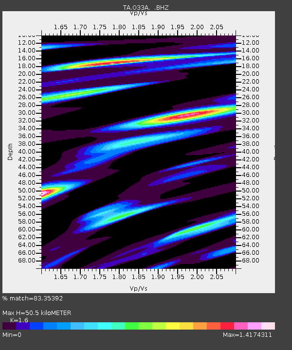
O33A Hebron, NE, USA - Earthquake Result Viewer
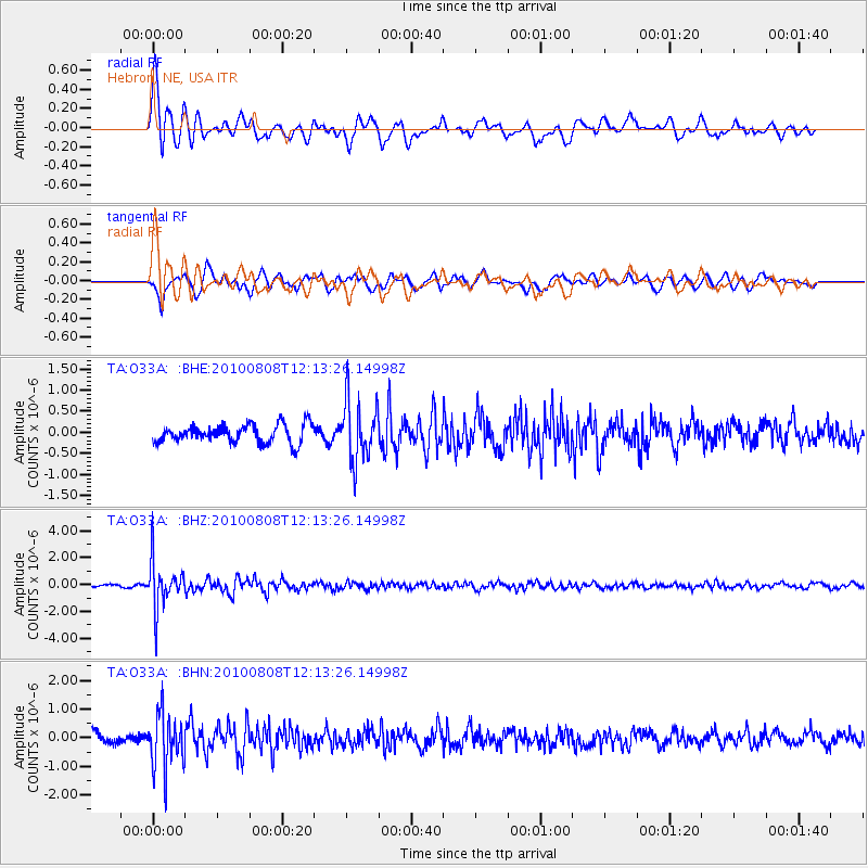
Earthquake location: Andreanof Islands, Aleutian Is.
Earthquake latitude/longitude: 51.3/-178.6
Earthquake time(UTC): 2010/08/08 (220) 12:04:28 GMT
Earthquake Depth: 29 km
Earthquake Magnitude: 5.7 MB, 5.0 MS, 5.4 MW, 5.8 ML
Earthquake Catalog/Contributor: WHDF/NEIC
Network: TA USArray Transportable Network (new EarthScope stations)
Station: O33A Hebron, NE, USA
Lat/Lon: 40.08 N/97.58 W
Elevation: 480 m
Distance: 54.9 deg
Az: 67.838 deg
Baz: 310.768 deg
Ray Param: 0.06509266
Estimated Moho Depth: 50.5 km
Estimated Crust Vp/Vs: 1.60
Assumed Crust Vp: 6.498 km/s
Estimated Crust Vs: 4.061 km/s
Estimated Crust Poisson's Ratio: 0.18
Radial Match: 83.35392 %
Radial Bump: 400
Transverse Match: 77.28399 %
Transverse Bump: 400
SOD ConfigId: 319893
Insert Time: 2011-01-05 19:03:00.756 +0000
GWidth: 2.5
Max Bumps: 400
Tol: 0.001

Signal To Noise

ChannelStoNSTALTA
TA:O33A: :BHZ:20100808T12:13:26.14998Z14.9751731.7677237E-61.1804362E-7
TA:O33A: :BHN:20100808T12:13:26.14998Z5.53579.660946E-71.7452078E-7
TA:O33A: :BHE:20100808T12:13:26.14998Z3.3544647.167398E-72.1366746E-7
Arrivals
Ps5.0 SECOND
PpPs19 SECOND
PsPs/PpSs24 SECOND