You are here: Home > Network List > AZ - ANZA Regional Network Stations List
> Station BZN AZ.BZN > Earthquake Result Viewer
BZN AZ.BZN - Earthquake Result Viewer

| Earthquake location: |
Solomon Islands |
| Earthquake latitude/longitude: |
-9.3/158.7 |
| Earthquake time(UTC): |
1997/10/10 (283) 18:45:52 GMT |
| Earthquake Depth: |
33 km |
| Earthquake Magnitude: |
5.4 MB, 5.7 MS, 6.0 UNKNOWN, 5.8 MW |
| Earthquake Catalog/Contributor: |
WHDF/NEIC |
|
| Network: |
AZ ANZA Regional Network |
| Station: |
BZN AZ.BZN |
| Lat/Lon: |
33.49 N/116.67 W |
| Elevation: |
1301 m |
|
| Distance: |
90.6 deg |
| Az: |
56.306 deg |
| Baz: |
259.311 deg |
| Ray Param: |
0.041656617 |
| Estimated Moho Depth: |
10.0 km |
| Estimated Crust Vp/Vs: |
1.60 |
| Assumed Crust Vp: |
6.264 km/s |
| Estimated Crust Vs: |
3.915 km/s |
| Estimated Crust Poisson's Ratio: |
0.18 |
|
| Radial Match: |
100.00001 % |
| Radial Bump: |
2 |
| Transverse Match: |
100.0 % |
| Transverse Bump: |
2 |
| SOD ConfigId: |
9875 |
| Insert Time: |
2010-02-26 18:42:31.310 +0000 |
| GWidth: |
2.5 |
| Max Bumps: |
400 |
| Tol: |
0.001 |
|
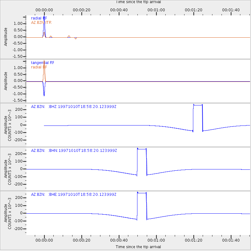
Signal To Noise
| Channel | StoN | STA | LTA |
| AZ:BZN: :BHN:19971010T18:58:20.123999Z | 1.876957 | 0.0023682094 | 0.001261728 |
| AZ:BZN: :BHE:19971010T18:58:20.123999Z | 1.8760961 | 0.0023654797 | 0.001260852 |
| AZ:BZN: :BHZ:19971010T18:58:20.123999Z | 1.8766131 | 0.0023669265 | 0.0012612757 |
| Arrivals |
| Ps | 1.0 SECOND |
| PpPs | 4.1 SECOND |
| PsPs/PpSs | 5.0 SECOND |


