You are here: Home > Network List > CN - Canadian National Seismograph Network Stations List
> Station INK INUVIK, NT > Earthquake Result Viewer
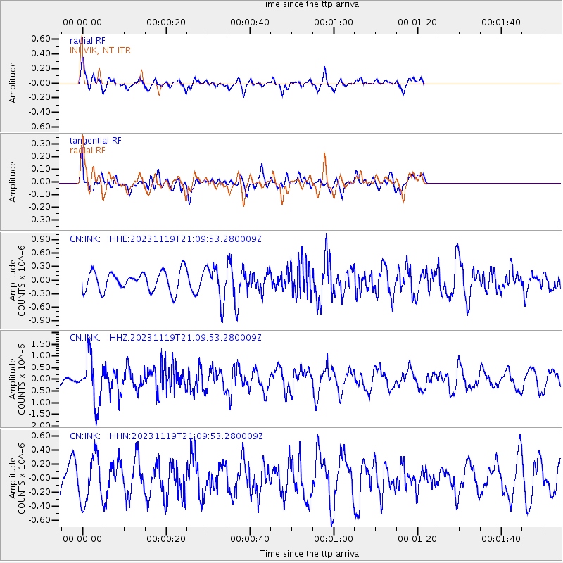
INK INUVIK, NT - Earthquake Result Viewer
*The percent match for this event was below the threshold and hence no stack was calculated.
| Earthquake location: |
Hokkaido, Japan Region |
| Earthquake latitude/longitude: |
41.2/142.2 |
| Earthquake time(UTC): |
2023/11/19 (323) 21:01:31 GMT |
| Earthquake Depth: |
53 km |
| Earthquake Magnitude: |
6.0 Mww |
| Earthquake Catalog/Contributor: |
NEIC PDE/us |
|
| Network: |
CN Canadian National Seismograph Network |
| Station: |
INK INUVIK, NT |
| Lat/Lon: |
68.31 N/133.53 W |
| Elevation: |
44 m |
|
| Distance: |
50.4 deg |
| Az: |
28.675 deg |
| Baz: |
282.993 deg |
| Ray Param: |
$rayparam |
*The percent match for this event was below the threshold and hence was not used in the summary stack. |
|
| Radial Match: |
72.41888 % |
| Radial Bump: |
400 |
| Transverse Match: |
55.84406 % |
| Transverse Bump: |
400 |
| SOD ConfigId: |
31937991 |
| Insert Time: |
2023-12-03 21:14:54.014 +0000 |
| GWidth: |
2.5 |
| Max Bumps: |
400 |
| Tol: |
0.001 |
|
Signal To Noise
| Channel | StoN | STA | LTA |
| CN:INK: :HHZ:20231119T21:09:53.280009Z | 3.8287551 | 9.709076E-7 | 2.5358312E-7 |
| CN:INK: :HHN:20231119T21:09:53.280009Z | 1.497568 | 3.175525E-7 | 2.1204545E-7 |
| CN:INK: :HHE:20231119T21:09:53.280009Z | 1.7935671 | 3.8403329E-7 | 2.1411705E-7 |
| Arrivals |
| Ps | |
| PpPs | |
| PsPs/PpSs | |


