You are here: Home > Network List > GS - US Geological Survey Networks Stations List
> Station ASL9 Albuquerque, New Mexico, USA > Earthquake Result Viewer
ASL9 Albuquerque, New Mexico, USA - Earthquake Result Viewer
| Earthquake location: |
Peru-Ecuador Border Region |
| Earthquake latitude/longitude: |
-2.2/-77.0 |
| Earthquake time(UTC): |
2019/02/22 (053) 10:17:22 GMT |
| Earthquake Depth: |
132 km |
| Earthquake Magnitude: |
7.5 mww |
| Earthquake Catalog/Contributor: |
NEIC PDE/us |
|
| Network: |
GS US Geological Survey Networks |
| Station: |
ASL9 Albuquerque, New Mexico, USA |
| Lat/Lon: |
34.95 N/106.46 W |
| Elevation: |
1820 m |
|
| Distance: |
46.1 deg |
| Az: |
325.936 deg |
| Baz: |
137.052 deg |
| Ray Param: |
0.07038269 |
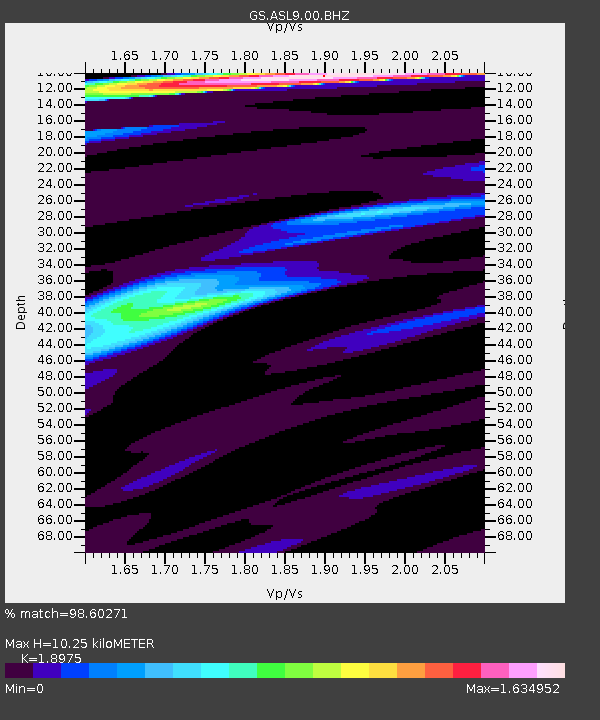
| Estimated Moho Depth: |
10.25 km |
| Estimated Crust Vp/Vs: |
1.90 |
| Assumed Crust Vp: |
6.502 km/s |
| Estimated Crust Vs: |
3.426 km/s |
| Estimated Crust Poisson's Ratio: |
0.31 |
|
| Radial Match: |
98.60271 % |
| Radial Bump: |
327 |
| Transverse Match: |
92.19201 % |
| Transverse Bump: |
400 |
| SOD ConfigId: |
3313551 |
| Insert Time: |
2019-03-08 10:22:34.876 +0000 |
| GWidth: |
2.5 |
| Max Bumps: |
400 |
| Tol: |
0.001 |
|

Signal To Noise
| Channel | StoN | STA | LTA |
| GS:ASL9:00:BHZ:20190222T10:25:02.869015Z | 42.85449 | 4.7919502E-6 | 1.118191E-7 |
| GS:ASL9:00:BH1:20190222T10:25:02.869015Z | 16.914543 | 3.1741504E-6 | 1.8765807E-7 |
| GS:ASL9:00:BH2:20190222T10:25:02.869015Z | 9.381796 | 1.5418589E-6 | 1.643458E-7 |
| Arrivals |
| Ps | 1.5 SECOND |
| PpPs | 4.3 SECOND |
| PsPs/PpSs | 5.8 SECOND |


