You are here: Home > Network List > GS - US Geological Survey Networks Stations List
> Station KAN01 Ward Farm, Argonia, KS, USA > Earthquake Result Viewer
KAN01 Ward Farm, Argonia, KS, USA - Earthquake Result Viewer
| Earthquake location: |
Peru-Ecuador Border Region |
| Earthquake latitude/longitude: |
-2.2/-77.0 |
| Earthquake time(UTC): |
2019/02/22 (053) 10:17:22 GMT |
| Earthquake Depth: |
132 km |
| Earthquake Magnitude: |
7.5 mww |
| Earthquake Catalog/Contributor: |
NEIC PDE/us |
|
| Network: |
GS US Geological Survey Networks |
| Station: |
KAN01 Ward Farm, Argonia, KS, USA |
| Lat/Lon: |
37.15 N/97.76 W |
| Elevation: |
360 m |
|
| Distance: |
43.6 deg |
| Az: |
335.799 deg |
| Baz: |
149.155 deg |
| Ray Param: |
0.071945116 |
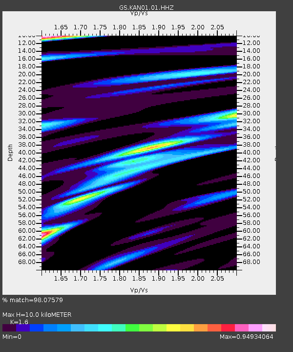
| Estimated Moho Depth: |
10.0 km |
| Estimated Crust Vp/Vs: |
1.60 |
| Assumed Crust Vp: |
6.483 km/s |
| Estimated Crust Vs: |
4.052 km/s |
| Estimated Crust Poisson's Ratio: |
0.18 |
|
| Radial Match: |
98.07579 % |
| Radial Bump: |
283 |
| Transverse Match: |
75.59404 % |
| Transverse Bump: |
372 |
| SOD ConfigId: |
3313551 |
| Insert Time: |
2019-03-08 10:22:45.974 +0000 |
| GWidth: |
2.5 |
| Max Bumps: |
400 |
| Tol: |
0.001 |
|

Signal To Noise
| Channel | StoN | STA | LTA |
| GS:KAN01:01:HHZ:20190222T10:24:43.269985Z | 116.22206 | 2.4099592E-5 | 2.0735814E-7 |
| GS:KAN01:01:HHN:20190222T10:24:43.269985Z | 16.966398 | 7.700304E-6 | 4.5385616E-7 |
| GS:KAN01:01:HHE:20190222T10:24:43.269985Z | 3.9375567 | 8.004825E-6 | 2.0329421E-6 |
| Arrivals |
| Ps | 1.0 SECOND |
| PpPs | 3.7 SECOND |
| PsPs/PpSs | 4.7 SECOND |


