You are here: Home > Network List > GS - US Geological Survey Networks Stations List
> Station KAN05 Bluff City North Station > Earthquake Result Viewer
KAN05 Bluff City North Station - Earthquake Result Viewer

| Earthquake location: |
Peru-Ecuador Border Region |
| Earthquake latitude/longitude: |
-2.2/-77.0 |
| Earthquake time(UTC): |
2019/02/22 (053) 10:17:22 GMT |
| Earthquake Depth: |
132 km |
| Earthquake Magnitude: |
7.5 mww |
| Earthquake Catalog/Contributor: |
NEIC PDE/us |
|
| Network: |
GS US Geological Survey Networks |
| Station: |
KAN05 Bluff City North Station |
| Lat/Lon: |
37.11 N/97.87 W |
| Elevation: |
348 m |
|
| Distance: |
43.6 deg |
| Az: |
335.653 deg |
| Baz: |
148.982 deg |
| Ray Param: |
0.07194011 |
| Estimated Moho Depth: |
10.5 km |
| Estimated Crust Vp/Vs: |
1.60 |
| Assumed Crust Vp: |
6.483 km/s |
| Estimated Crust Vs: |
4.052 km/s |
| Estimated Crust Poisson's Ratio: |
0.18 |
|
| Radial Match: |
96.29486 % |
| Radial Bump: |
365 |
| Transverse Match: |
68.56882 % |
| Transverse Bump: |
400 |
| SOD ConfigId: |
3313551 |
| Insert Time: |
2019-03-08 10:22:49.251 +0000 |
| GWidth: |
2.5 |
| Max Bumps: |
400 |
| Tol: |
0.001 |
|
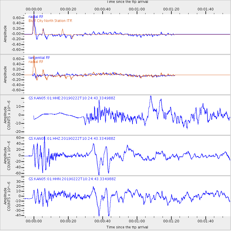
Signal To Noise
| Channel | StoN | STA | LTA |
| GS:KAN05:01:HHZ:20190222T10:24:43.334988Z | 115.81588 | 2.4239382E-5 | 2.092924E-7 |
| GS:KAN05:01:HHN:20190222T10:24:43.334988Z | 4.162247 | 8.732263E-6 | 2.0979683E-6 |
| GS:KAN05:01:HHE:20190222T10:24:43.334988Z | 2.8313138 | 5.4163224E-6 | 1.9130066E-6 |
| Arrivals |
| Ps | 1.0 SECOND |
| PpPs | 3.9 SECOND |
| PsPs/PpSs | 5.0 SECOND |


