You are here: Home > Network List > US - United States National Seismic Network Stations List
> Station EGMT Eagleton, Montana, USA > Earthquake Result Viewer
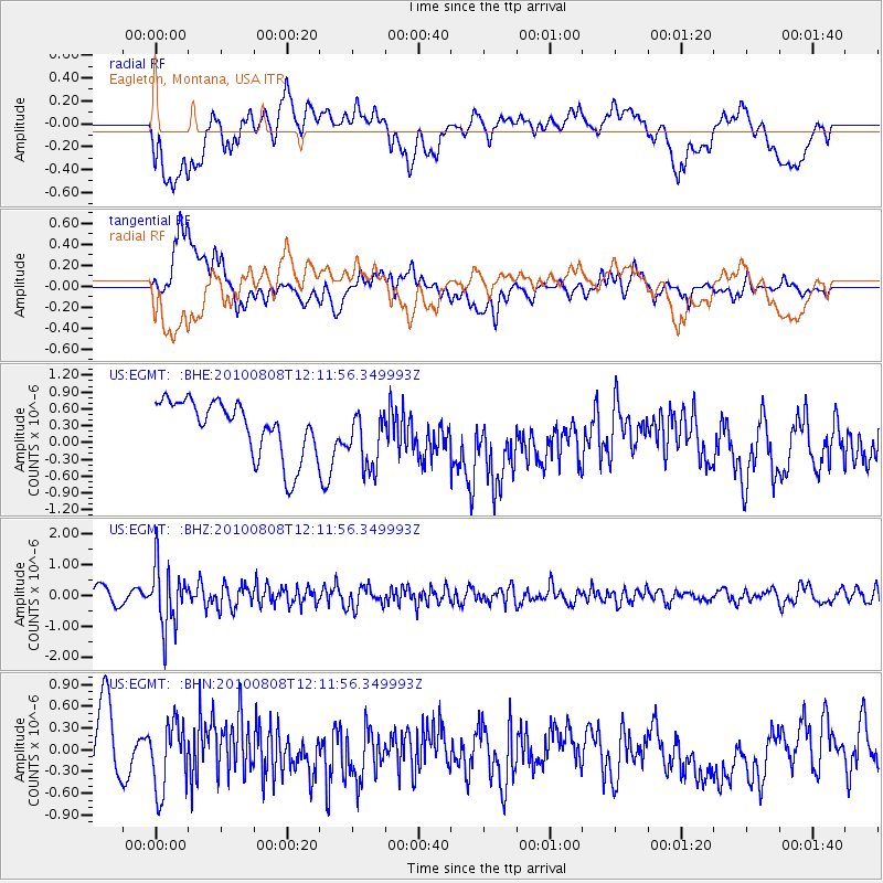
EGMT Eagleton, Montana, USA - Earthquake Result Viewer
*The percent match for this event was below the threshold and hence no stack was calculated.
| Earthquake location: |
Andreanof Islands, Aleutian Is. |
| Earthquake latitude/longitude: |
51.3/-178.6 |
| Earthquake time(UTC): |
2010/08/08 (220) 12:04:28 GMT |
| Earthquake Depth: |
29 km |
| Earthquake Magnitude: |
5.7 MB, 5.0 MS, 5.4 MW, 5.8 ML |
| Earthquake Catalog/Contributor: |
WHDF/NEIC |
|
| Network: |
US United States National Seismic Network |
| Station: |
EGMT Eagleton, Montana, USA |
| Lat/Lon: |
48.02 N/109.75 W |
| Elevation: |
1055 m |
|
| Distance: |
43.2 deg |
| Az: |
66.195 deg |
| Baz: |
301.215 deg |
| Ray Param: |
$rayparam |
*The percent match for this event was below the threshold and hence was not used in the summary stack. |
|
| Radial Match: |
39.501244 % |
| Radial Bump: |
400 |
| Transverse Match: |
62.651325 % |
| Transverse Bump: |
400 |
| SOD ConfigId: |
319893 |
| Insert Time: |
2011-01-05 19:09:40.653 +0000 |
| GWidth: |
2.5 |
| Max Bumps: |
400 |
| Tol: |
0.001 |
|
Signal To Noise
| Channel | StoN | STA | LTA |
| US:EGMT: :BHZ:20100808T12:11:56.349993Z | 3.190673 | 9.893492E-7 | 3.1007542E-7 |
| US:EGMT: :BHN:20100808T12:11:56.349993Z | 0.7682166 | 4.62748E-7 | 6.023666E-7 |
| US:EGMT: :BHE:20100808T12:11:56.349993Z | 1.1112735 | 5.5080676E-7 | 4.9565364E-7 |
| Arrivals |
| Ps | |
| PpPs | |
| PsPs/PpSs | |


