You are here: Home > Network List > US - United States National Seismic Network Stations List
> Station HDIL Hopedale, Illinois, USA > Earthquake Result Viewer
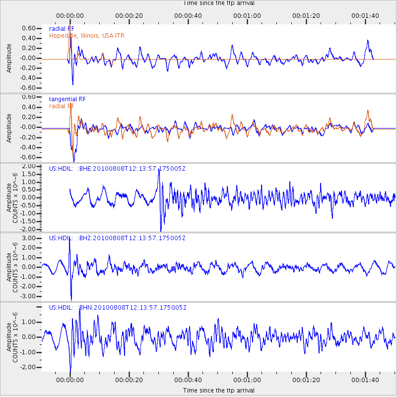
HDIL Hopedale, Illinois, USA - Earthquake Result Viewer
*The percent match for this event was below the threshold and hence no stack was calculated.
| Earthquake location: |
Andreanof Islands, Aleutian Is. |
| Earthquake latitude/longitude: |
51.3/-178.6 |
| Earthquake time(UTC): |
2010/08/08 (220) 12:04:28 GMT |
| Earthquake Depth: |
29 km |
| Earthquake Magnitude: |
5.7 MB, 5.0 MS, 5.4 MW, 5.8 ML |
| Earthquake Catalog/Contributor: |
WHDF/NEIC |
|
| Network: |
US United States National Seismic Network |
| Station: |
HDIL Hopedale, Illinois, USA |
| Lat/Lon: |
40.56 N/89.29 W |
| Elevation: |
219 m |
|
| Distance: |
59.3 deg |
| Az: |
62.37 deg |
| Baz: |
313.143 deg |
| Ray Param: |
$rayparam |
*The percent match for this event was below the threshold and hence was not used in the summary stack. |
|
| Radial Match: |
71.75126 % |
| Radial Bump: |
400 |
| Transverse Match: |
88.94691 % |
| Transverse Bump: |
400 |
| SOD ConfigId: |
319893 |
| Insert Time: |
2011-01-05 19:09:56.111 +0000 |
| GWidth: |
2.5 |
| Max Bumps: |
400 |
| Tol: |
0.001 |
|
Signal To Noise
| Channel | StoN | STA | LTA |
| US:HDIL: :BHZ:20100808T12:13:57.175005Z | 3.5386224 | 1.1486264E-6 | 3.245971E-7 |
| US:HDIL: :BHN:20100808T12:13:57.175005Z | 3.7868361 | 9.551196E-7 | 2.5222099E-7 |
| US:HDIL: :BHE:20100808T12:13:57.175005Z | 2.8750832 | 9.538185E-7 | 3.317533E-7 |
| Arrivals |
| Ps | |
| PpPs | |
| PsPs/PpSs | |


