You are here: Home > Network List > GT - Global Telemetered Seismograph Network (USAF/USGS) Stations List
> Station PLCA Paso Flores, Argentina > Earthquake Result Viewer
PLCA Paso Flores, Argentina - Earthquake Result Viewer
| Earthquake location: |
Peru-Ecuador Border Region |
| Earthquake latitude/longitude: |
-2.2/-77.0 |
| Earthquake time(UTC): |
2019/02/22 (053) 10:17:22 GMT |
| Earthquake Depth: |
132 km |
| Earthquake Magnitude: |
7.5 mww |
| Earthquake Catalog/Contributor: |
NEIC PDE/us |
|
| Network: |
GT Global Telemetered Seismograph Network (USAF/USGS) |
| Station: |
PLCA Paso Flores, Argentina |
| Lat/Lon: |
40.73 S/70.55 W |
| Elevation: |
1050 m |
|
| Distance: |
38.8 deg |
| Az: |
172.143 deg |
| Baz: |
349.645 deg |
| Ray Param: |
0.074886754 |
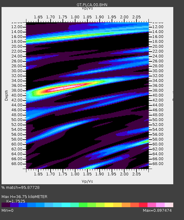
| Estimated Moho Depth: |
36.75 km |
| Estimated Crust Vp/Vs: |
1.75 |
| Assumed Crust Vp: |
6.597 km/s |
| Estimated Crust Vs: |
3.765 km/s |
| Estimated Crust Poisson's Ratio: |
0.26 |
|
| Radial Match: |
95.87728 % |
| Radial Bump: |
349 |
| Transverse Match: |
81.774254 % |
| Transverse Bump: |
400 |
| SOD ConfigId: |
3313551 |
| Insert Time: |
2019-03-08 10:23:15.886 +0000 |
| GWidth: |
2.5 |
| Max Bumps: |
400 |
| Tol: |
0.001 |
|

Signal To Noise
| Channel | StoN | STA | LTA |
| GT:PLCA:00:BHZ:20190222T10:24:03.899014Z | 59.93597 | 4.0019484E-5 | 6.6770394E-7 |
| GT:PLCA:00:BHN:20190222T10:24:03.899014Z | 52.618702 | 2.5782072E-5 | 4.8997924E-7 |
| GT:PLCA:00:BHE:20190222T10:24:03.899014Z | 26.355503 | 5.858979E-6 | 2.2230572E-7 |
| Arrivals |
| Ps | 4.5 SECOND |
| PpPs | 14 SECOND |
| PsPs/PpSs | 19 SECOND |


