You are here: Home > Network List > IU - Global Seismograph Network (GSN - IRIS/USGS) Stations List
> Station JOHN Johnston Island, USA > Earthquake Result Viewer
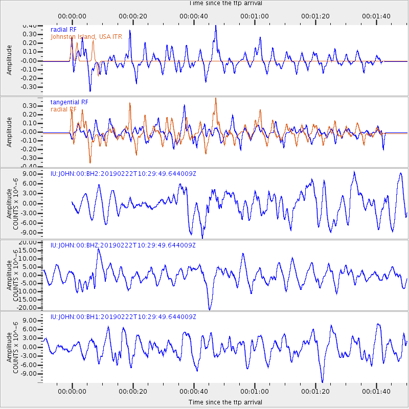
JOHN Johnston Island, USA - Earthquake Result Viewer
*The percent match for this event was below the threshold and hence no stack was calculated.
| Earthquake location: |
Peru-Ecuador Border Region |
| Earthquake latitude/longitude: |
-2.2/-77.0 |
| Earthquake time(UTC): |
2019/02/22 (053) 10:17:22 GMT |
| Earthquake Depth: |
132 km |
| Earthquake Magnitude: |
7.5 mww |
| Earthquake Catalog/Contributor: |
NEIC PDE/us |
|
| Network: |
IU Global Seismograph Network (GSN - IRIS/USGS) |
| Station: |
JOHN Johnston Island, USA |
| Lat/Lon: |
16.73 N/169.53 W |
| Elevation: |
2.0 m |
|
| Distance: |
93.0 deg |
| Az: |
286.543 deg |
| Baz: |
91.378 deg |
| Ray Param: |
$rayparam |
*The percent match for this event was below the threshold and hence was not used in the summary stack. |
|
| Radial Match: |
81.174255 % |
| Radial Bump: |
400 |
| Transverse Match: |
64.6469 % |
| Transverse Bump: |
400 |
| SOD ConfigId: |
3313551 |
| Insert Time: |
2019-03-08 10:23:36.091 +0000 |
| GWidth: |
2.5 |
| Max Bumps: |
400 |
| Tol: |
0.001 |
|
Signal To Noise
| Channel | StoN | STA | LTA |
| IU:JOHN:00:BHZ:20190222T10:29:49.644009Z | 2.0610566 | 5.670409E-6 | 2.7512144E-6 |
| IU:JOHN:00:BH1:20190222T10:29:49.644009Z | 0.70330787 | 1.8378615E-6 | 2.613168E-6 |
| IU:JOHN:00:BH2:20190222T10:29:49.644009Z | 0.6322016 | 1.5843193E-6 | 2.5060351E-6 |
| Arrivals |
| Ps | |
| PpPs | |
| PsPs/PpSs | |


