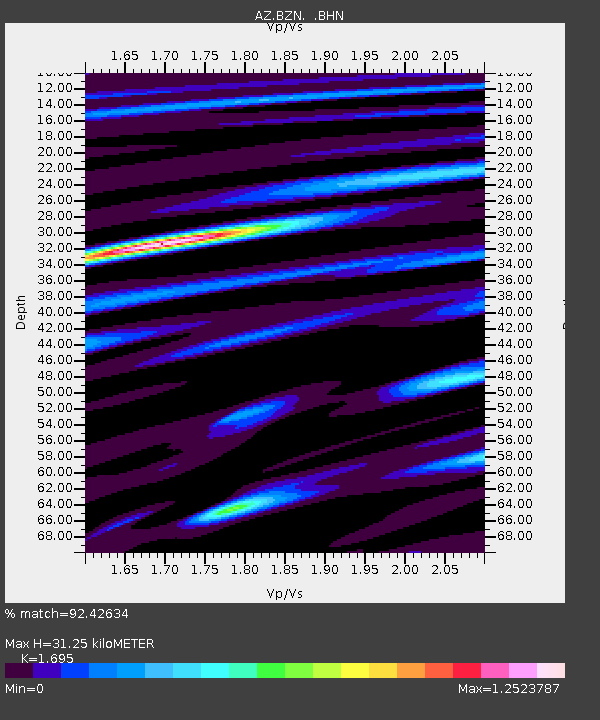
BZN AZ.BZN - Earthquake Result Viewer

Earthquake location: Southeast Of Loyalty Islands
Earthquake latitude/longitude: -22.3/170.9
Earthquake time(UTC): 1998/01/04 (004) 06:11:58 GMT
Earthquake Depth: 101 km
Earthquake Magnitude: 6.4 MB, 7.4 UNKNOWN, 7.3 ME
Earthquake Catalog/Contributor: WHDF/NEIC
Network: AZ ANZA Regional Network
Station: BZN AZ.BZN
Lat/Lon: 33.49 N/116.67 W
Elevation: 1301 m
Distance: 88.5 deg
Az: 52.838 deg
Baz: 242.026 deg
Ray Param: 0.042343833
Estimated Moho Depth: 31.25 km
Estimated Crust Vp/Vs: 1.70
Assumed Crust Vp: 6.264 km/s
Estimated Crust Vs: 3.695 km/s
Estimated Crust Poisson's Ratio: 0.23
Radial Match: 92.42634 %
Radial Bump: 400
Transverse Match: 88.8912 %
Transverse Bump: 400
SOD ConfigId: 9875
Insert Time: 2010-02-26 18:42:58.184 +0000
GWidth: 2.5
Max Bumps: 400
Tol: 0.001

Signal To Noise

ChannelStoNSTALTA
AZ:BZN: :BHN:19980104T06:24:08.775Z1.52841083.413949E-72.2336594E-7
AZ:BZN: :BHE:19980104T06:24:08.775Z0.986306552.8476046E-72.8871395E-7
AZ:BZN: :BHZ:19980104T06:24:08.775Z3.24526988.071568E-72.4871795E-7
Arrivals
Ps3.5 SECOND
PpPs13 SECOND
PsPs/PpSs17 SECOND