You are here: Home > Network List > AK - Alaska Regional Network Stations List
> Station TGL Tana Glacier > Earthquake Result Viewer
TGL Tana Glacier - Earthquake Result Viewer
| Earthquake location: |
Vanuatu Islands |
| Earthquake latitude/longitude: |
-17.5/168.1 |
| Earthquake time(UTC): |
2010/08/10 (222) 05:23:44 GMT |
| Earthquake Depth: |
25 km |
| Earthquake Magnitude: |
6.4 MB, 7.3 MS, 7.3 MW, 7.2 MW |
| Earthquake Catalog/Contributor: |
WHDF/NEIC |
|
| Network: |
AK Alaska Regional Network |
| Station: |
TGL Tana Glacier |
| Lat/Lon: |
60.75 N/142.83 W |
| Elevation: |
1260 m |
|
| Distance: |
87.4 deg |
| Az: |
21.813 deg |
| Baz: |
226.215 deg |
| Ray Param: |
0.043343056 |
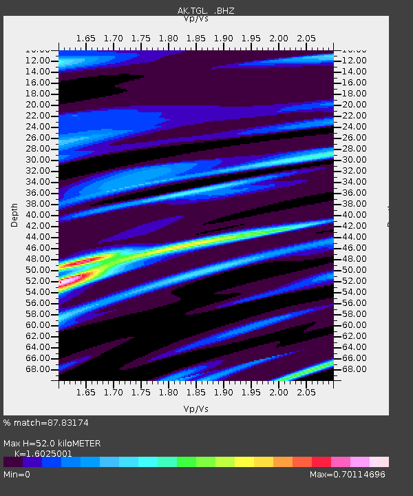
| Estimated Moho Depth: |
52.0 km |
| Estimated Crust Vp/Vs: |
1.60 |
| Assumed Crust Vp: |
6.566 km/s |
| Estimated Crust Vs: |
4.097 km/s |
| Estimated Crust Poisson's Ratio: |
0.18 |
|
| Radial Match: |
87.83174 % |
| Radial Bump: |
397 |
| Transverse Match: |
58.785355 % |
| Transverse Bump: |
400 |
| SOD ConfigId: |
319893 |
| Insert Time: |
2011-01-05 19:13:43.931 +0000 |
| GWidth: |
2.5 |
| Max Bumps: |
400 |
| Tol: |
0.001 |
|

Signal To Noise
| Channel | StoN | STA | LTA |
| AK:TGL: :BHZ:20100810T05:35:58.407979Z | 20.890577 | 4.7406597E-6 | 2.2692812E-7 |
| AK:TGL: :BHN:20100810T05:35:58.407979Z | 1.6800728 | 1.082489E-6 | 6.443108E-7 |
| AK:TGL: :BHE:20100810T05:35:58.407979Z | 0.6318334 | 1.0872461E-6 | 1.7207799E-6 |
| Arrivals |
| Ps | 4.9 SECOND |
| PpPs | 20 SECOND |
| PsPs/PpSs | 25 SECOND |


