You are here: Home > Network List > IW - Intermountain West Stations List
> Station TPAW Teton Pass, Wyoming, USA > Earthquake Result Viewer
TPAW Teton Pass, Wyoming, USA - Earthquake Result Viewer
| Earthquake location: |
Peru-Ecuador Border Region |
| Earthquake latitude/longitude: |
-2.2/-77.0 |
| Earthquake time(UTC): |
2019/02/22 (053) 10:17:22 GMT |
| Earthquake Depth: |
132 km |
| Earthquake Magnitude: |
7.5 mww |
| Earthquake Catalog/Contributor: |
NEIC PDE/us |
|
| Network: |
IW Intermountain West |
| Station: |
TPAW Teton Pass, Wyoming, USA |
| Lat/Lon: |
43.49 N/110.95 W |
| Elevation: |
2512 m |
|
| Distance: |
54.7 deg |
| Az: |
330.166 deg |
| Baz: |
136.917 deg |
| Ray Param: |
0.064823754 |
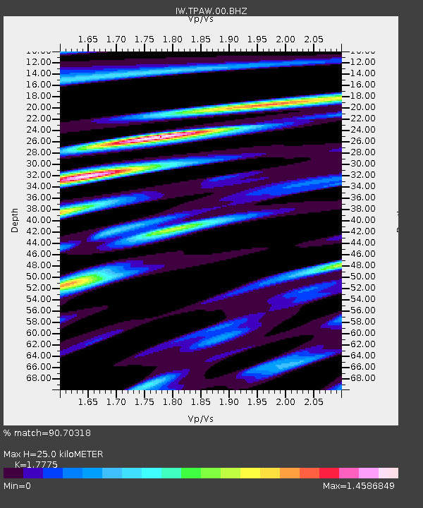
| Estimated Moho Depth: |
25.0 km |
| Estimated Crust Vp/Vs: |
1.78 |
| Assumed Crust Vp: |
6.207 km/s |
| Estimated Crust Vs: |
3.492 km/s |
| Estimated Crust Poisson's Ratio: |
0.27 |
|
| Radial Match: |
90.70318 % |
| Radial Bump: |
400 |
| Transverse Match: |
77.30003 % |
| Transverse Bump: |
400 |
| SOD ConfigId: |
3313551 |
| Insert Time: |
2019-03-08 10:24:14.569 +0000 |
| GWidth: |
2.5 |
| Max Bumps: |
400 |
| Tol: |
0.001 |
|

Signal To Noise
| Channel | StoN | STA | LTA |
| IW:TPAW:00:BHZ:20190222T10:26:07.540005Z | 20.282068 | 4.3905993E-6 | 2.164769E-7 |
| IW:TPAW:00:BH1:20190222T10:26:07.540005Z | 18.196602 | 1.6247766E-6 | 8.9290104E-8 |
| IW:TPAW:00:BH2:20190222T10:26:07.540005Z | 4.3835187 | 1.5301529E-6 | 3.4906952E-7 |
| Arrivals |
| Ps | 3.3 SECOND |
| PpPs | 11 SECOND |
| PsPs/PpSs | 14 SECOND |


