You are here: Home > Network List > AZ - ANZA Regional Network Stations List
> Station SCI2 San Clemente Island, CA, USA > Earthquake Result Viewer
SCI2 San Clemente Island, CA, USA - Earthquake Result Viewer
| Earthquake location: |
Vanuatu Islands |
| Earthquake latitude/longitude: |
-17.5/168.1 |
| Earthquake time(UTC): |
2010/08/10 (222) 05:23:44 GMT |
| Earthquake Depth: |
25 km |
| Earthquake Magnitude: |
6.4 MB, 7.3 MS, 7.3 MW, 7.2 MW |
| Earthquake Catalog/Contributor: |
WHDF/NEIC |
|
| Network: |
AZ ANZA Regional Network |
| Station: |
SCI2 San Clemente Island, CA, USA |
| Lat/Lon: |
32.92 N/118.49 W |
| Elevation: |
486 m |
|
| Distance: |
86.2 deg |
| Az: |
53.907 deg |
| Baz: |
246.428 deg |
| Ray Param: |
0.04421097 |
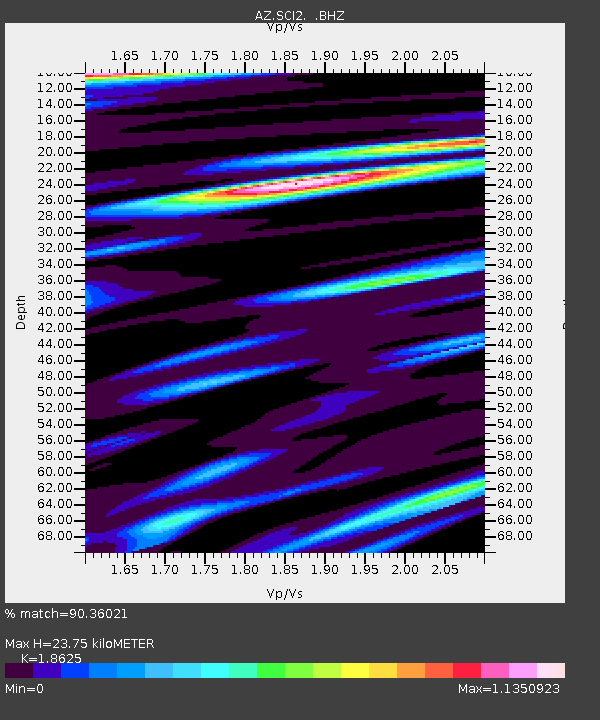
| Estimated Moho Depth: |
23.75 km |
| Estimated Crust Vp/Vs: |
1.86 |
| Assumed Crust Vp: |
6.048 km/s |
| Estimated Crust Vs: |
3.247 km/s |
| Estimated Crust Poisson's Ratio: |
0.30 |
|
| Radial Match: |
90.36021 % |
| Radial Bump: |
400 |
| Transverse Match: |
78.126755 % |
| Transverse Bump: |
400 |
| SOD ConfigId: |
319893 |
| Insert Time: |
2011-01-05 19:16:51.580 +0000 |
| GWidth: |
2.5 |
| Max Bumps: |
400 |
| Tol: |
0.001 |
|

Signal To Noise
| Channel | StoN | STA | LTA |
| AZ:SCI2: :BHZ:20100810T05:35:52.596028Z | 6.1223717 | 2.259668E-6 | 3.6908378E-7 |
| AZ:SCI2: :BHN:20100810T05:35:52.596028Z | 1.5378052 | 8.3890785E-7 | 5.455228E-7 |
| AZ:SCI2: :BHE:20100810T05:35:52.596028Z | 3.4728627 | 9.720364E-7 | 2.7989486E-7 |
| Arrivals |
| Ps | 3.5 SECOND |
| PpPs | 11 SECOND |
| PsPs/PpSs | 14 SECOND |


