You are here: Home > Network List > AK - Alaska Regional Network Stations List
> Station MCAR McCarthy VSAT, AK, USA > Earthquake Result Viewer
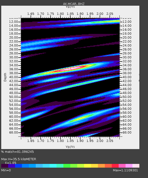
MCAR McCarthy VSAT, AK, USA - Earthquake Result Viewer
| Earthquake location: |
Vanuatu Islands |
| Earthquake latitude/longitude: |
-15.0/168.0 |
| Earthquake time(UTC): |
2023/11/22 (326) 04:47:31 GMT |
| Earthquake Depth: |
13 km |
| Earthquake Magnitude: |
6.7 mww |
| Earthquake Catalog/Contributor: |
NEIC PDE/us |
|
| Network: |
AK Alaska Regional Network |
| Station: |
MCAR McCarthy VSAT, AK, USA |
| Lat/Lon: |
61.38 N/143.02 W |
| Elevation: |
447 m |
|
| Distance: |
85.4 deg |
| Az: |
21.379 deg |
| Baz: |
227.035 deg |
| Ray Param: |
0.044779167 |
| Estimated Moho Depth: |
35.5 km |
| Estimated Crust Vp/Vs: |
1.85 |
| Assumed Crust Vp: |
6.566 km/s |
| Estimated Crust Vs: |
3.549 km/s |
| Estimated Crust Poisson's Ratio: |
0.29 |
|
| Radial Match: |
81.096245 % |
| Radial Bump: |
400 |
| Transverse Match: |
73.13865 % |
| Transverse Bump: |
400 |
| SOD ConfigId: |
33182351 |
| Insert Time: |
2023-12-06 04:52:28.312 +0000 |
| GWidth: |
2.5 |
| Max Bumps: |
400 |
| Tol: |
0.001 |
|

Signal To Noise
| Channel | StoN | STA | LTA |
| AK:MCAR: :BHZ:20231122T04:59:37.14803Z | 2.9287586 | 1.8575728E-6 | 6.342526E-7 |
| AK:MCAR: :BHN:20231122T04:59:37.14803Z | 0.69099575 | 5.0956965E-7 | 7.374426E-7 |
| AK:MCAR: :BHE:20231122T04:59:37.14803Z | 0.75220764 | 5.145775E-7 | 6.840897E-7 |
| Arrivals |
| Ps | 4.7 SECOND |
| PpPs | 15 SECOND |
| PsPs/PpSs | 20 SECOND |


