You are here: Home > Network List > NM - Cooperative New Madrid Seismic Network Stations List
> Station UTMT Martin, TN > Earthquake Result Viewer
UTMT Martin, TN - Earthquake Result Viewer
| Earthquake location: |
Peru-Ecuador Border Region |
| Earthquake latitude/longitude: |
-2.2/-77.0 |
| Earthquake time(UTC): |
2019/02/22 (053) 10:17:22 GMT |
| Earthquake Depth: |
132 km |
| Earthquake Magnitude: |
7.5 mww |
| Earthquake Catalog/Contributor: |
NEIC PDE/us |
|
| Network: |
NM Cooperative New Madrid Seismic Network |
| Station: |
UTMT Martin, TN |
| Lat/Lon: |
36.35 N/88.86 W |
| Elevation: |
110 m |
|
| Distance: |
39.9 deg |
| Az: |
345.037 deg |
| Baz: |
161.362 deg |
| Ray Param: |
0.07424627 |
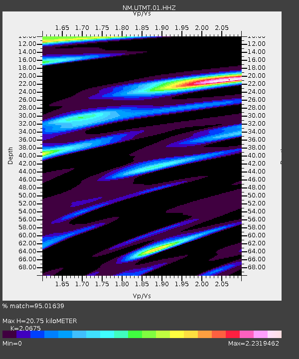
| Estimated Moho Depth: |
20.75 km |
| Estimated Crust Vp/Vs: |
2.07 |
| Assumed Crust Vp: |
6.444 km/s |
| Estimated Crust Vs: |
3.117 km/s |
| Estimated Crust Poisson's Ratio: |
0.35 |
|
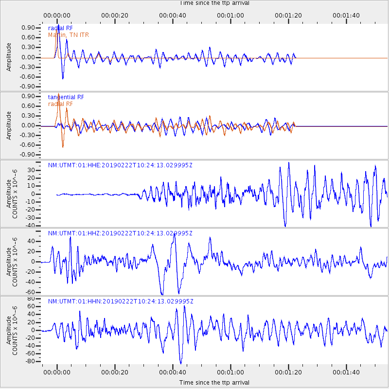
| Radial Match: |
95.01639 % |
| Radial Bump: |
359 |
| Transverse Match: |
89.170685 % |
| Transverse Bump: |
400 |
| SOD ConfigId: |
3313551 |
| Insert Time: |
2019-03-08 10:25:07.392 +0000 |
| GWidth: |
2.5 |
| Max Bumps: |
400 |
| Tol: |
0.001 |
|
Signal To Noise
| Channel | StoN | STA | LTA |
| NM:UTMT:01:HHZ:20190222T10:24:13.029995Z | 74.0384 | 1.9564928E-5 | 2.642538E-7 |
| NM:UTMT:01:HHN:20190222T10:24:13.029995Z | 17.193205 | 1.4654206E-5 | 8.5232546E-7 |
| NM:UTMT:01:HHE:20190222T10:24:13.029995Z | 9.940976 | 5.6074878E-6 | 5.6407816E-7 |
| Arrivals |
| Ps | 3.6 SECOND |
| PpPs | 9.3 SECOND |
| PsPs/PpSs | 13 SECOND |


