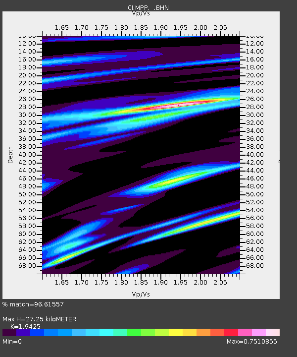
MPP McPhearson Peak - Earthquake Result Viewer
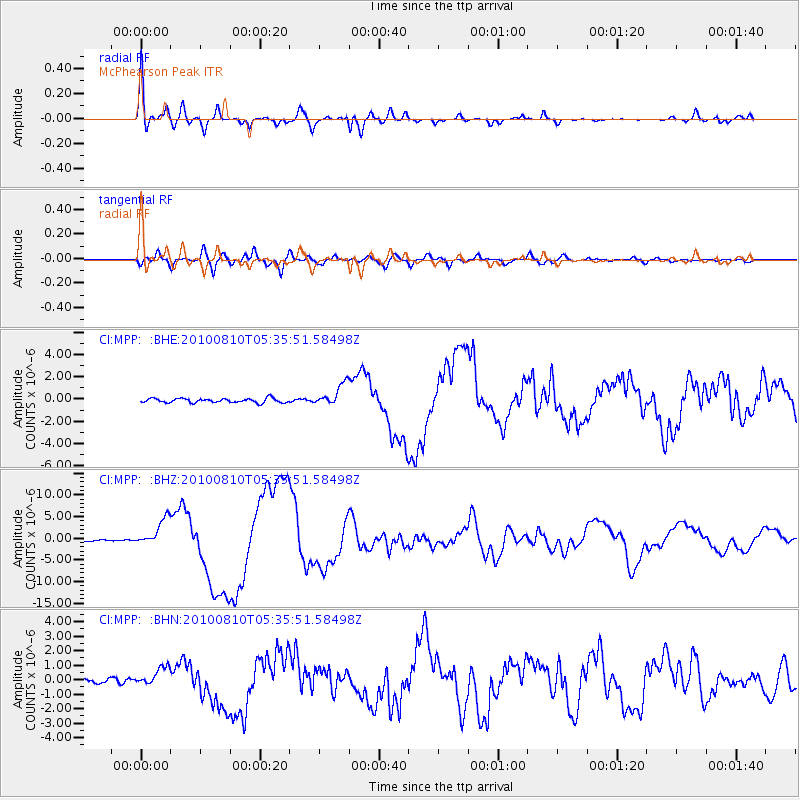
Earthquake location: Vanuatu Islands
Earthquake latitude/longitude: -17.5/168.1
Earthquake time(UTC): 2010/08/10 (222) 05:23:44 GMT
Earthquake Depth: 25 km
Earthquake Magnitude: 6.4 MB, 7.3 MS, 7.3 MW, 7.2 MW
Earthquake Catalog/Contributor: WHDF/NEIC
Network: CI Caltech Regional Seismic Network
Station: MPP McPhearson Peak
Lat/Lon: 34.89 N/119.81 W
Elevation: 1739 m
Distance: 86.0 deg
Az: 51.655 deg
Baz: 245.538 deg
Ray Param: 0.044357106
Estimated Moho Depth: 27.25 km
Estimated Crust Vp/Vs: 1.94
Assumed Crust Vp: 6.1 km/s
Estimated Crust Vs: 3.14 km/s
Estimated Crust Poisson's Ratio: 0.32
Radial Match: 96.61557 %
Radial Bump: 400
Transverse Match: 86.14712 %
Transverse Bump: 400
SOD ConfigId: 319893
Insert Time: 2011-01-05 19:21:11.400 +0000
GWidth: 2.5
Max Bumps: 400
Tol: 0.001

Signal To Noise

ChannelStoNSTALTA
CI:MPP: :BHZ:20100810T05:35:51.58498Z25.9661183.201449E-61.2329333E-7
CI:MPP: :BHN:20100810T05:35:51.58498Z3.79329356.341383E-71.6717354E-7
CI:MPP: :BHE:20100810T05:35:51.58498Z5.2172399.934247E-71.9041195E-7
Arrivals
Ps4.3 SECOND
PpPs13 SECOND
PsPs/PpSs17 SECOND