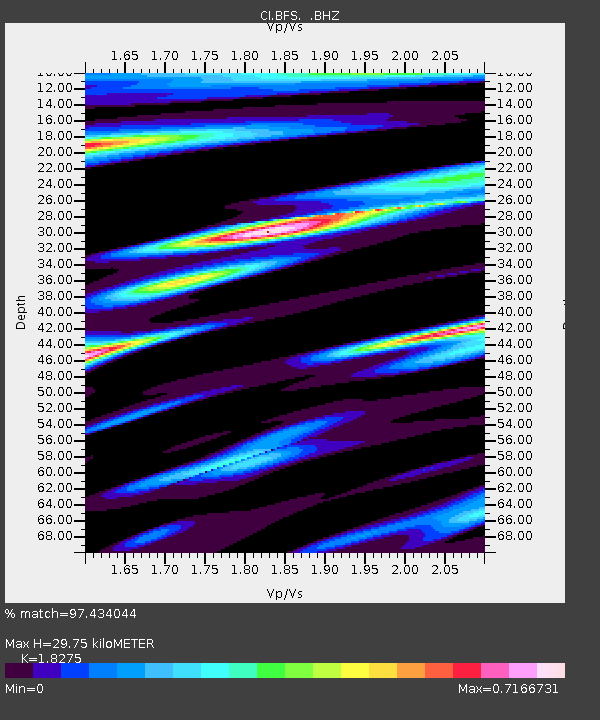
BFS Mt Baldy Forest Station - Earthquake Result Viewer

Earthquake location: Vanuatu Islands
Earthquake latitude/longitude: -17.5/168.1
Earthquake time(UTC): 2010/08/10 (222) 05:23:44 GMT
Earthquake Depth: 25 km
Earthquake Magnitude: 6.4 MB, 7.3 MS, 7.3 MW, 7.2 MW
Earthquake Catalog/Contributor: WHDF/NEIC
Network: CI Caltech Regional Seismic Network
Station: BFS Mt Baldy Forest Station
Lat/Lon: 34.24 N/117.66 W
Elevation: 1312 m
Distance: 87.3 deg
Az: 52.968 deg
Baz: 246.832 deg
Ray Param: 0.0433712
Estimated Moho Depth: 29.75 km
Estimated Crust Vp/Vs: 1.83
Assumed Crust Vp: 6.276 km/s
Estimated Crust Vs: 3.434 km/s
Estimated Crust Poisson's Ratio: 0.29
Radial Match: 97.434044 %
Radial Bump: 400
Transverse Match: 88.54719 %
Transverse Bump: 400
SOD ConfigId: 319893
Insert Time: 2011-01-05 19:21:35.792 +0000
GWidth: 2.5
Max Bumps: 400
Tol: 0.001

Signal To Noise

ChannelStoNSTALTA
CI:BFS: :BHZ:20100810T05:35:58.21999Z47.9838333.0846868E-66.4285956E-8
CI:BFS: :BHN:20100810T05:35:58.21999Z12.1022725.290053E-74.3711243E-8
CI:BFS: :BHE:20100810T05:35:58.21999Z15.0201119.16441E-76.101427E-8
Arrivals
Ps4.0 SECOND
PpPs13 SECOND
PsPs/PpSs17 SECOND