You are here: Home > Network List > CI - Caltech Regional Seismic Network Stations List
> Station PDM Parker Dam, Lake Havasu City, AZ, USA > Earthquake Result Viewer
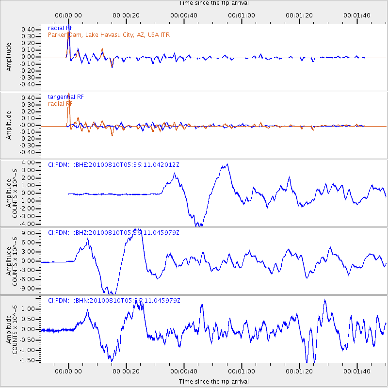
PDM Parker Dam, Lake Havasu City, AZ, USA - Earthquake Result Viewer

| Earthquake location: |
Vanuatu Islands |
| Earthquake latitude/longitude: |
-17.5/168.1 |
| Earthquake time(UTC): |
2010/08/10 (222) 05:23:44 GMT |
| Earthquake Depth: |
25 km |
| Earthquake Magnitude: |
6.4 MB, 7.3 MS, 7.3 MW, 7.2 MW |
| Earthquake Catalog/Contributor: |
WHDF/NEIC |
|
| Network: |
CI Caltech Regional Seismic Network |
| Station: |
PDM Parker Dam, Lake Havasu City, AZ, USA |
| Lat/Lon: |
34.30 N/114.14 W |
| Elevation: |
144 m |
|
| Distance: |
90.1 deg |
| Az: |
54.008 deg |
| Baz: |
248.827 deg |
| Ray Param: |
0.041698016 |
| Estimated Moho Depth: |
27.5 km |
| Estimated Crust Vp/Vs: |
1.76 |
| Assumed Crust Vp: |
6.276 km/s |
| Estimated Crust Vs: |
3.556 km/s |
| Estimated Crust Poisson's Ratio: |
0.26 |
|
| Radial Match: |
97.42245 % |
| Radial Bump: |
400 |
| Transverse Match: |
89.86829 % |
| Transverse Bump: |
400 |
| SOD ConfigId: |
319893 |
| Insert Time: |
2011-01-05 19:21:37.932 +0000 |
| GWidth: |
2.5 |
| Max Bumps: |
400 |
| Tol: |
0.001 |
|
Signal To Noise
| Channel | StoN | STA | LTA |
| CI:PDM: :BHZ:20100810T05:36:11.045979Z | 38.68293 | 2.2917259E-6 | 5.9243852E-8 |
| CI:PDM: :BHN:20100810T05:36:11.045979Z | 4.9088864 | 2.0868033E-7 | 4.2510727E-8 |
| CI:PDM: :BHE:20100810T05:36:11.042012Z | 15.781967 | 7.2511386E-7 | 4.5945722E-8 |
| Arrivals |
| Ps | 3.4 SECOND |
| PpPs | 12 SECOND |
| PsPs/PpSs | 15 SECOND |


