You are here: Home > Network List > CI - Caltech Regional Seismic Network Stations List
> Station TUQ Turquiose Mountain, Baker, CA, USA > Earthquake Result Viewer
TUQ Turquiose Mountain, Baker, CA, USA - Earthquake Result Viewer
| Earthquake location: |
Vanuatu Islands |
| Earthquake latitude/longitude: |
-17.5/168.1 |
| Earthquake time(UTC): |
2010/08/10 (222) 05:23:44 GMT |
| Earthquake Depth: |
25 km |
| Earthquake Magnitude: |
6.4 MB, 7.3 MS, 7.3 MW, 7.2 MW |
| Earthquake Catalog/Contributor: |
WHDF/NEIC |
|
| Network: |
CI Caltech Regional Seismic Network |
| Station: |
TUQ Turquiose Mountain, Baker, CA, USA |
| Lat/Lon: |
35.44 N/115.92 W |
| Elevation: |
1350 m |
|
| Distance: |
89.1 deg |
| Az: |
52.416 deg |
| Baz: |
247.801 deg |
| Ray Param: |
0.04206123 |
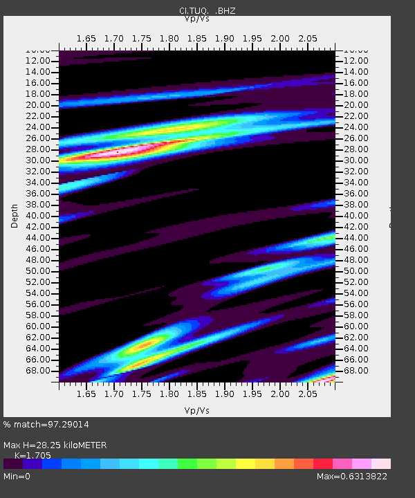
| Estimated Moho Depth: |
28.25 km |
| Estimated Crust Vp/Vs: |
1.71 |
| Assumed Crust Vp: |
6.276 km/s |
| Estimated Crust Vs: |
3.681 km/s |
| Estimated Crust Poisson's Ratio: |
0.24 |
|
| Radial Match: |
97.29014 % |
| Radial Bump: |
378 |
| Transverse Match: |
87.52032 % |
| Transverse Bump: |
400 |
| SOD ConfigId: |
319893 |
| Insert Time: |
2011-01-05 19:21:50.086 +0000 |
| GWidth: |
2.5 |
| Max Bumps: |
400 |
| Tol: |
0.001 |
|
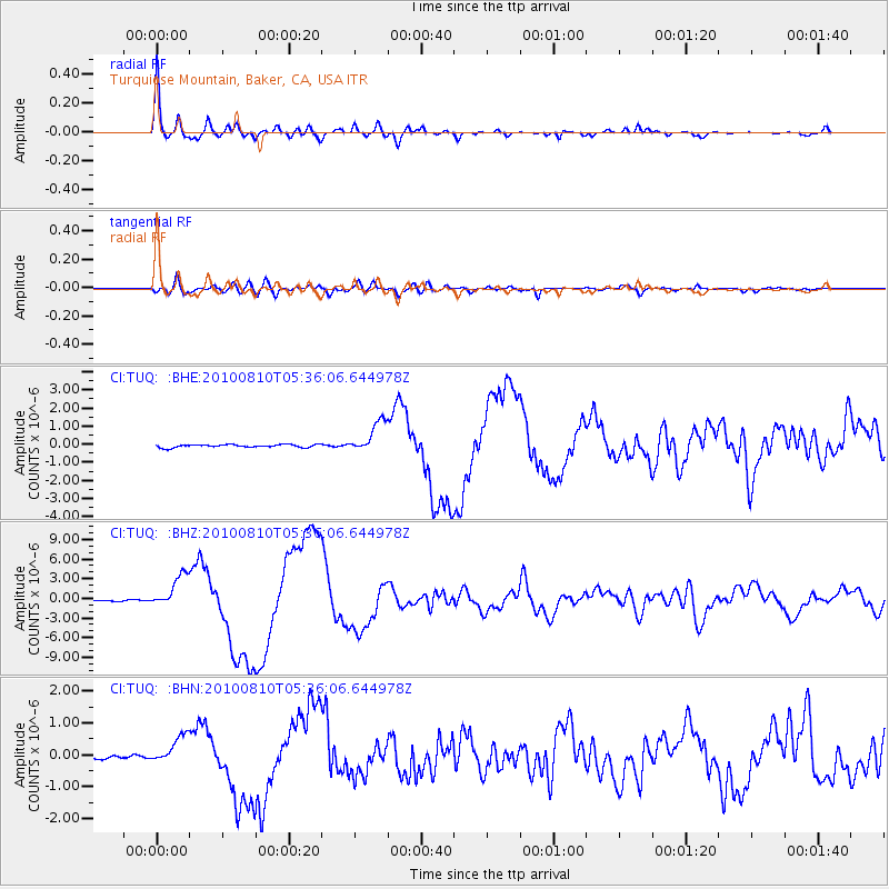
Signal To Noise
| Channel | StoN | STA | LTA |
| CI:TUQ: :BHZ:20100810T05:36:06.644978Z | 35.645763 | 2.5589359E-6 | 7.178794E-8 |
| CI:TUQ: :BHN:20100810T05:36:06.644978Z | 9.258852 | 4.4910686E-7 | 4.8505672E-8 |
| CI:TUQ: :BHE:20100810T05:36:06.644978Z | 11.187698 | 8.8200994E-7 | 7.883748E-8 |
| Arrivals |
| Ps | 3.2 SECOND |
| PpPs | 12 SECOND |
| PsPs/PpSs | 15 SECOND |


