You are here: Home > Network List > G - GEOSCOPE Stations List
> Station INU Inuyama, Japan > Earthquake Result Viewer
INU Inuyama, Japan - Earthquake Result Viewer
| Earthquake location: |
Vanuatu Islands |
| Earthquake latitude/longitude: |
-15.0/168.0 |
| Earthquake time(UTC): |
2023/11/22 (326) 04:47:31 GMT |
| Earthquake Depth: |
13 km |
| Earthquake Magnitude: |
6.7 mww |
| Earthquake Catalog/Contributor: |
NEIC PDE/us |
|
| Network: |
G GEOSCOPE |
| Station: |
INU Inuyama, Japan |
| Lat/Lon: |
35.35 N/137.03 E |
| Elevation: |
132 m |
|
| Distance: |
58.0 deg |
| Az: |
330.297 deg |
| Baz: |
144.141 deg |
| Ray Param: |
0.06311163 |
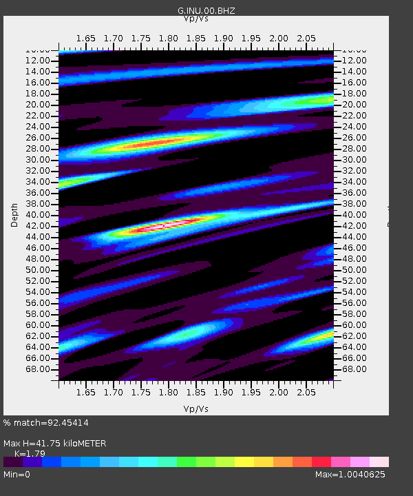
| Estimated Moho Depth: |
41.75 km |
| Estimated Crust Vp/Vs: |
1.79 |
| Assumed Crust Vp: |
6.461 km/s |
| Estimated Crust Vs: |
3.61 km/s |
| Estimated Crust Poisson's Ratio: |
0.27 |
|
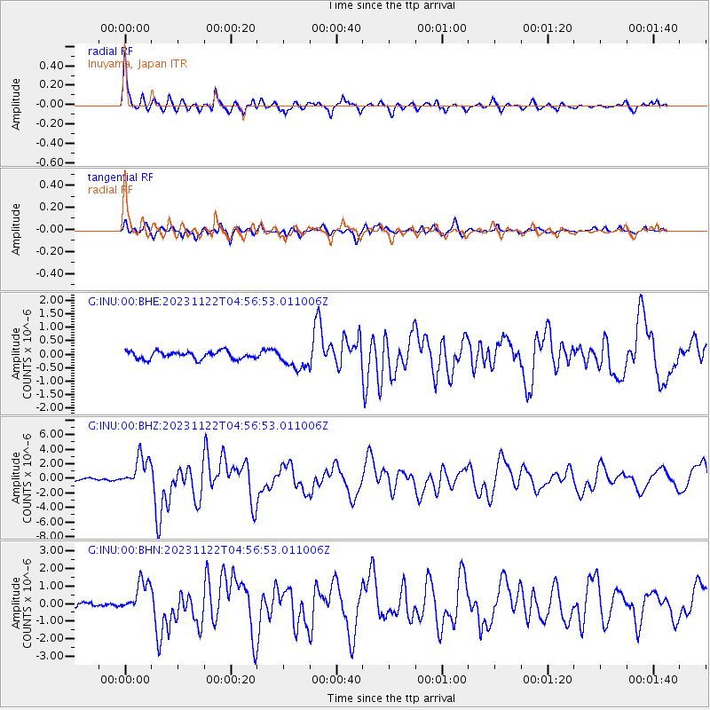
| Radial Match: |
92.45414 % |
| Radial Bump: |
357 |
| Transverse Match: |
80.49105 % |
| Transverse Bump: |
400 |
| SOD ConfigId: |
33182351 |
| Insert Time: |
2023-12-06 05:02:48.932 +0000 |
| GWidth: |
2.5 |
| Max Bumps: |
400 |
| Tol: |
0.001 |
|
Signal To Noise
| Channel | StoN | STA | LTA |
| G:INU:00:BHZ:20231122T04:56:53.011006Z | 13.170565 | 2.142372E-6 | 1.6266365E-7 |
| G:INU:00:BHN:20231122T04:56:53.011006Z | 7.0186996 | 8.986826E-7 | 1.2804118E-7 |
| G:INU:00:BHE:20231122T04:56:53.011006Z | 2.8030324 | 3.9417625E-7 | 1.4062493E-7 |
| Arrivals |
| Ps | 5.4 SECOND |
| PpPs | 17 SECOND |
| PsPs/PpSs | 23 SECOND |


