You are here: Home > Network List > GS - US Geological Survey Networks Stations List
> Station MCA04 MCA04, Monte Cristo Range, NV > Earthquake Result Viewer
MCA04 MCA04, Monte Cristo Range, NV - Earthquake Result Viewer
| Earthquake location: |
Vanuatu Islands |
| Earthquake latitude/longitude: |
-15.0/168.0 |
| Earthquake time(UTC): |
2023/11/22 (326) 04:47:31 GMT |
| Earthquake Depth: |
13 km |
| Earthquake Magnitude: |
6.7 mww |
| Earthquake Catalog/Contributor: |
NEIC PDE/us |
|
| Network: |
GS US Geological Survey Networks |
| Station: |
MCA04 MCA04, Monte Cristo Range, NV |
| Lat/Lon: |
38.08 N/117.71 W |
| Elevation: |
1662 m |
|
| Distance: |
87.2 deg |
| Az: |
49.527 deg |
| Baz: |
248.678 deg |
| Ray Param: |
0.043468215 |
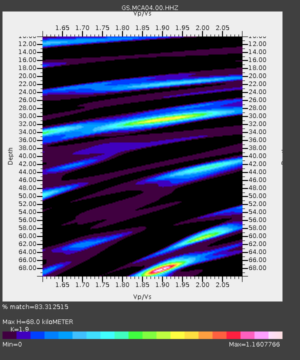
| Estimated Moho Depth: |
68.0 km |
| Estimated Crust Vp/Vs: |
1.90 |
| Assumed Crust Vp: |
6.276 km/s |
| Estimated Crust Vs: |
3.303 km/s |
| Estimated Crust Poisson's Ratio: |
0.31 |
|
| Radial Match: |
83.312515 % |
| Radial Bump: |
400 |
| Transverse Match: |
81.476364 % |
| Transverse Bump: |
400 |
| SOD ConfigId: |
33182351 |
| Insert Time: |
2023-12-06 05:03:22.499 +0000 |
| GWidth: |
2.5 |
| Max Bumps: |
400 |
| Tol: |
0.001 |
|

Signal To Noise
| Channel | StoN | STA | LTA |
| GS:MCA04:00:HHZ:20231122T04:59:46.058979Z | 6.6562185 | 1.5942654E-6 | 2.3951517E-7 |
| GS:MCA04:00:HH1:20231122T04:59:46.058979Z | 1.2535702 | 2.8438333E-7 | 2.2685873E-7 |
| GS:MCA04:00:HH2:20231122T04:59:46.058979Z | 2.8346717 | 4.7586227E-7 | 1.678721E-7 |
| Arrivals |
| Ps | 9.9 SECOND |
| PpPs | 31 SECOND |
| PsPs/PpSs | 41 SECOND |


