You are here: Home > Network List > IW - Intermountain West Stations List
> Station MOOW Moose Ponds, Wyoming, USA > Earthquake Result Viewer
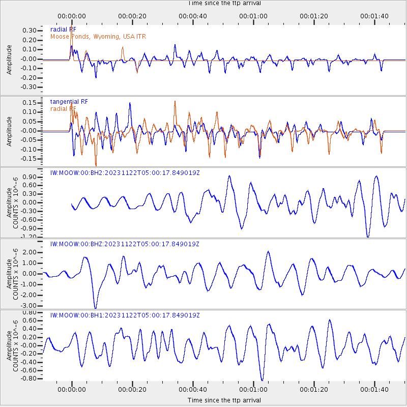
MOOW Moose Ponds, Wyoming, USA - Earthquake Result Viewer
*The percent match for this event was below the threshold and hence no stack was calculated.
| Earthquake location: |
Vanuatu Islands |
| Earthquake latitude/longitude: |
-15.0/168.0 |
| Earthquake time(UTC): |
2023/11/22 (326) 04:47:31 GMT |
| Earthquake Depth: |
13 km |
| Earthquake Magnitude: |
6.7 mww |
| Earthquake Catalog/Contributor: |
NEIC PDE/us |
|
| Network: |
IW Intermountain West |
| Station: |
MOOW Moose Ponds, Wyoming, USA |
| Lat/Lon: |
43.75 N/110.74 W |
| Elevation: |
2128 m |
|
| Distance: |
94.1 deg |
| Az: |
45.901 deg |
| Baz: |
253.271 deg |
| Ray Param: |
$rayparam |
*The percent match for this event was below the threshold and hence was not used in the summary stack. |
|
| Radial Match: |
68.27317 % |
| Radial Bump: |
400 |
| Transverse Match: |
60.02003 % |
| Transverse Bump: |
400 |
| SOD ConfigId: |
33182351 |
| Insert Time: |
2023-12-06 05:04:48.472 +0000 |
| GWidth: |
2.5 |
| Max Bumps: |
400 |
| Tol: |
0.001 |
|
Signal To Noise
| Channel | StoN | STA | LTA |
| IW:MOOW:00:BHZ:20231122T05:00:17.849019Z | 3.2006605 | 8.042517E-7 | 2.512768E-7 |
| IW:MOOW:00:BH1:20231122T05:00:17.849019Z | 1.5636816 | 2.7234907E-7 | 1.7417169E-7 |
| IW:MOOW:00:BH2:20231122T05:00:17.849019Z | 1.6201831 | 2.258508E-7 | 1.3939831E-7 |
| Arrivals |
| Ps | |
| PpPs | |
| PsPs/PpSs | |


