You are here: Home > Network List > G - GEOSCOPE Stations List
> Station KIP Kipapa - Hawaii, USA > Earthquake Result Viewer
KIP Kipapa - Hawaii, USA - Earthquake Result Viewer
| Earthquake location: |
Vanuatu Islands |
| Earthquake latitude/longitude: |
-17.5/168.1 |
| Earthquake time(UTC): |
2010/08/10 (222) 05:23:44 GMT |
| Earthquake Depth: |
25 km |
| Earthquake Magnitude: |
6.4 MB, 7.3 MS, 7.3 MW, 7.2 MW |
| Earthquake Catalog/Contributor: |
WHDF/NEIC |
|
| Network: |
G GEOSCOPE |
| Station: |
KIP Kipapa - Hawaii, USA |
| Lat/Lon: |
21.42 N/158.01 W |
| Elevation: |
70 m |
|
| Distance: |
51.0 deg |
| Az: |
41.966 deg |
| Baz: |
223.214 deg |
| Ray Param: |
0.067631714 |
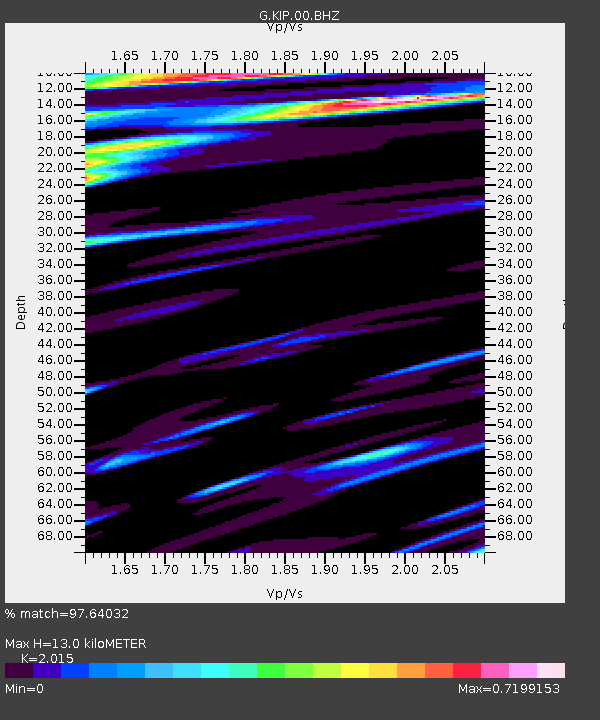
| Estimated Moho Depth: |
13.0 km |
| Estimated Crust Vp/Vs: |
2.02 |
| Assumed Crust Vp: |
4.24 km/s |
| Estimated Crust Vs: |
2.104 km/s |
| Estimated Crust Poisson's Ratio: |
0.34 |
|
| Radial Match: |
97.64032 % |
| Radial Bump: |
308 |
| Transverse Match: |
86.57625 % |
| Transverse Bump: |
400 |
| SOD ConfigId: |
319893 |
| Insert Time: |
2011-01-05 19:23:09.638 +0000 |
| GWidth: |
2.5 |
| Max Bumps: |
400 |
| Tol: |
0.001 |
|

Signal To Noise
| Channel | StoN | STA | LTA |
| G:KIP:00:BHZ:20100810T05:32:14.072987Z | 11.689676 | 6.181303E-6 | 5.2878306E-7 |
| G:KIP:00:BHN:20100810T05:32:14.072987Z | 3.958199 | 2.2360605E-6 | 5.649187E-7 |
| G:KIP:00:BHE:20100810T05:32:14.072987Z | 4.5895023 | 2.9069656E-6 | 6.333945E-7 |
| Arrivals |
| Ps | 3.2 SECOND |
| PpPs | 9.1 SECOND |
| PsPs/PpSs | 12 SECOND |


