You are here: Home > Network List > TX - Texas Seismological Network Stations List
> Station FW11 UT at Arlington > Earthquake Result Viewer
FW11 UT at Arlington - Earthquake Result Viewer
| Earthquake location: |
Peru-Ecuador Border Region |
| Earthquake latitude/longitude: |
-2.2/-77.0 |
| Earthquake time(UTC): |
2019/02/22 (053) 10:17:22 GMT |
| Earthquake Depth: |
132 km |
| Earthquake Magnitude: |
7.5 mww |
| Earthquake Catalog/Contributor: |
NEIC PDE/us |
|
| Network: |
TX Texas Seismological Network |
| Station: |
FW11 UT at Arlington |
| Lat/Lon: |
32.72 N/97.13 W |
| Elevation: |
198 m |
|
| Distance: |
39.6 deg |
| Az: |
332.964 deg |
| Baz: |
147.394 deg |
| Ray Param: |
0.07442442 |
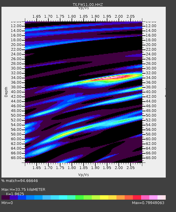
| Estimated Moho Depth: |
33.75 km |
| Estimated Crust Vp/Vs: |
1.96 |
| Assumed Crust Vp: |
6.38 km/s |
| Estimated Crust Vs: |
3.251 km/s |
| Estimated Crust Poisson's Ratio: |
0.32 |
|
| Radial Match: |
94.66646 % |
| Radial Bump: |
268 |
| Transverse Match: |
91.40943 % |
| Transverse Bump: |
283 |
| SOD ConfigId: |
3313551 |
| Insert Time: |
2019-03-08 10:25:55.577 +0000 |
| GWidth: |
2.5 |
| Max Bumps: |
400 |
| Tol: |
0.001 |
|
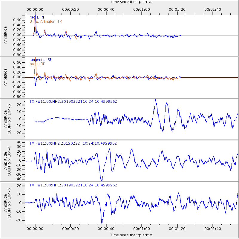
Signal To Noise
| Channel | StoN | STA | LTA |
| TX:FW11:00:HHZ:20190222T10:24:10.499996Z | 3.899636 | 1.098811E-5 | 2.817727E-6 |
| TX:FW11:00:HH1:20190222T10:24:10.499996Z | 1.1068896 | 3.945379E-6 | 3.5643834E-6 |
| TX:FW11:00:HH2:20190222T10:24:10.499996Z | 2.4093518 | 4.8795123E-6 | 2.0252385E-6 |
| Arrivals |
| Ps | 5.4 SECOND |
| PpPs | 15 SECOND |
| PsPs/PpSs | 20 SECOND |


