You are here: Home > Network List > TX - Texas Seismological Network Stations List
> Station FW13 Cleburne > Earthquake Result Viewer
FW13 Cleburne - Earthquake Result Viewer
| Earthquake location: |
Peru-Ecuador Border Region |
| Earthquake latitude/longitude: |
-2.2/-77.0 |
| Earthquake time(UTC): |
2019/02/22 (053) 10:17:22 GMT |
| Earthquake Depth: |
132 km |
| Earthquake Magnitude: |
7.5 mww |
| Earthquake Catalog/Contributor: |
NEIC PDE/us |
|
| Network: |
TX Texas Seismological Network |
| Station: |
FW13 Cleburne |
| Lat/Lon: |
32.35 N/97.43 W |
| Elevation: |
259 m |
|
| Distance: |
39.4 deg |
| Az: |
332.31 deg |
| Baz: |
146.728 deg |
| Ray Param: |
0.07451516 |
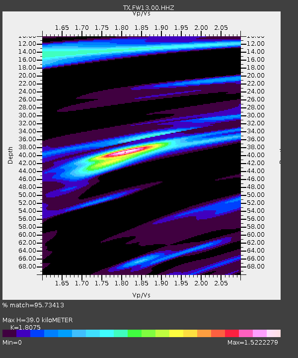
| Estimated Moho Depth: |
39.0 km |
| Estimated Crust Vp/Vs: |
1.81 |
| Assumed Crust Vp: |
6.38 km/s |
| Estimated Crust Vs: |
3.53 km/s |
| Estimated Crust Poisson's Ratio: |
0.28 |
|
| Radial Match: |
95.73413 % |
| Radial Bump: |
290 |
| Transverse Match: |
91.31942 % |
| Transverse Bump: |
400 |
| SOD ConfigId: |
3313551 |
| Insert Time: |
2019-03-08 10:25:58.730 +0000 |
| GWidth: |
2.5 |
| Max Bumps: |
400 |
| Tol: |
0.001 |
|

Signal To Noise
| Channel | StoN | STA | LTA |
| TX:FW13:00:HHZ:20190222T10:24:09.080013Z | 63.53228 | 1.0177447E-5 | 1.6019331E-7 |
| TX:FW13:00:HH1:20190222T10:24:09.080013Z | 12.5452585 | 2.3667228E-6 | 1.8865475E-7 |
| TX:FW13:00:HH2:20190222T10:24:09.080013Z | 14.411653 | 3.1307566E-6 | 2.1723785E-7 |
| Arrivals |
| Ps | 5.3 SECOND |
| PpPs | 16 SECOND |
| PsPs/PpSs | 21 SECOND |


