You are here: Home > Network List > UU - University of Utah Regional Network Stations List
> Station FOR2 Blundell East, UT, USA > Earthquake Result Viewer
FOR2 Blundell East, UT, USA - Earthquake Result Viewer
| Earthquake location: |
Vanuatu Islands |
| Earthquake latitude/longitude: |
-15.0/168.0 |
| Earthquake time(UTC): |
2023/11/22 (326) 04:47:31 GMT |
| Earthquake Depth: |
13 km |
| Earthquake Magnitude: |
6.7 mww |
| Earthquake Catalog/Contributor: |
NEIC PDE/us |
|
| Network: |
UU University of Utah Regional Network |
| Station: |
FOR2 Blundell East, UT, USA |
| Lat/Lon: |
38.49 N/112.87 W |
| Elevation: |
1760 m |
|
| Distance: |
91.0 deg |
| Az: |
50.425 deg |
| Baz: |
251.678 deg |
| Ray Param: |
0.041660838 |
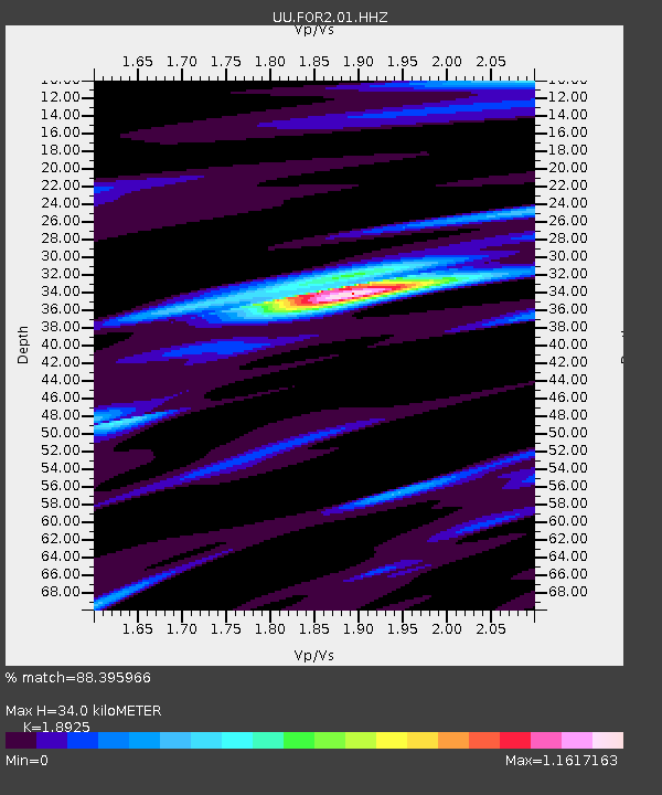
| Estimated Moho Depth: |
34.0 km |
| Estimated Crust Vp/Vs: |
1.89 |
| Assumed Crust Vp: |
6.276 km/s |
| Estimated Crust Vs: |
3.316 km/s |
| Estimated Crust Poisson's Ratio: |
0.31 |
|
| Radial Match: |
88.395966 % |
| Radial Bump: |
400 |
| Transverse Match: |
62.313107 % |
| Transverse Bump: |
400 |
| SOD ConfigId: |
33182351 |
| Insert Time: |
2023-12-06 05:13:11.116 +0000 |
| GWidth: |
2.5 |
| Max Bumps: |
400 |
| Tol: |
0.001 |
|

Signal To Noise
| Channel | StoN | STA | LTA |
| UU:FOR2:01:HHZ:20231122T05:00:03.524983Z | 2.9719932 | 9.972571E-7 | 3.3555162E-7 |
| UU:FOR2:01:HHN:20231122T05:00:03.524983Z | 1.0257717 | 5.7564506E-7 | 5.611824E-7 |
| UU:FOR2:01:HHE:20231122T05:00:03.524983Z | 1.94034 | 8.9358235E-7 | 4.6052872E-7 |
| Arrivals |
| Ps | 4.9 SECOND |
| PpPs | 15 SECOND |
| PsPs/PpSs | 20 SECOND |


