You are here: Home > Network List > IW - Intermountain West Stations List
> Station PLID Pearl Lake, Idaho, USA > Earthquake Result Viewer
PLID Pearl Lake, Idaho, USA - Earthquake Result Viewer
| Earthquake location: |
Vanuatu Islands |
| Earthquake latitude/longitude: |
-17.5/168.1 |
| Earthquake time(UTC): |
2010/08/10 (222) 05:23:44 GMT |
| Earthquake Depth: |
25 km |
| Earthquake Magnitude: |
6.4 MB, 7.3 MS, 7.3 MW, 7.2 MW |
| Earthquake Catalog/Contributor: |
WHDF/NEIC |
|
| Network: |
IW Intermountain West |
| Station: |
PLID Pearl Lake, Idaho, USA |
| Lat/Lon: |
45.09 N/116.00 W |
| Elevation: |
2164 m |
|
| Distance: |
92.7 deg |
| Az: |
43.465 deg |
| Baz: |
247.894 deg |
| Ray Param: |
0.04139951 |
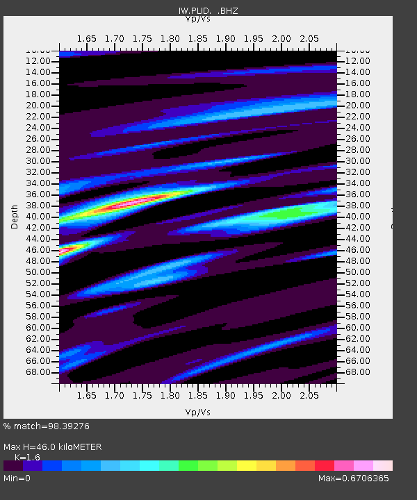
| Estimated Moho Depth: |
46.0 km |
| Estimated Crust Vp/Vs: |
1.60 |
| Assumed Crust Vp: |
6.571 km/s |
| Estimated Crust Vs: |
4.107 km/s |
| Estimated Crust Poisson's Ratio: |
0.18 |
|
| Radial Match: |
98.39276 % |
| Radial Bump: |
400 |
| Transverse Match: |
92.8564 % |
| Transverse Bump: |
400 |
| SOD ConfigId: |
319893 |
| Insert Time: |
2011-01-05 19:25:41.841 +0000 |
| GWidth: |
2.5 |
| Max Bumps: |
400 |
| Tol: |
0.001 |
|
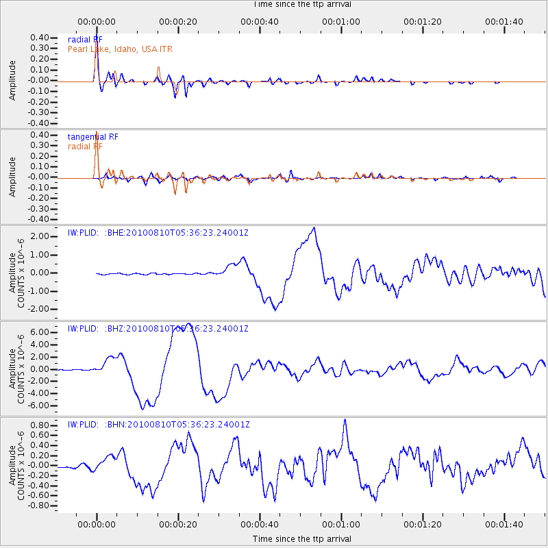
Signal To Noise
| Channel | StoN | STA | LTA |
| IW:PLID: :BHZ:20100810T05:36:23.24001Z | 32.2846 | 1.4498065E-6 | 4.490706E-8 |
| IW:PLID: :BHN:20100810T05:36:23.24001Z | 4.9011126 | 1.6069271E-7 | 3.2786986E-8 |
| IW:PLID: :BHE:20100810T05:36:23.24001Z | 12.987515 | 3.834893E-7 | 2.9527534E-8 |
| Arrivals |
| Ps | 4.3 SECOND |
| PpPs | 18 SECOND |
| PsPs/PpSs | 22 SECOND |


