You are here: Home > Network List > TX - Texas Seismological Network Stations List
> Station PB08 Permian Basin 08 > Earthquake Result Viewer
PB08 Permian Basin 08 - Earthquake Result Viewer
| Earthquake location: |
Peru-Ecuador Border Region |
| Earthquake latitude/longitude: |
-2.2/-77.0 |
| Earthquake time(UTC): |
2019/02/22 (053) 10:17:22 GMT |
| Earthquake Depth: |
132 km |
| Earthquake Magnitude: |
7.5 mww |
| Earthquake Catalog/Contributor: |
NEIC PDE/us |
|
| Network: |
TX Texas Seismological Network |
| Station: |
PB08 Permian Basin 08 |
| Lat/Lon: |
30.89 N/102.91 W |
| Elevation: |
926 m |
|
| Distance: |
41.1 deg |
| Az: |
325.201 deg |
| Baz: |
138.441 deg |
| Ray Param: |
0.0735001 |
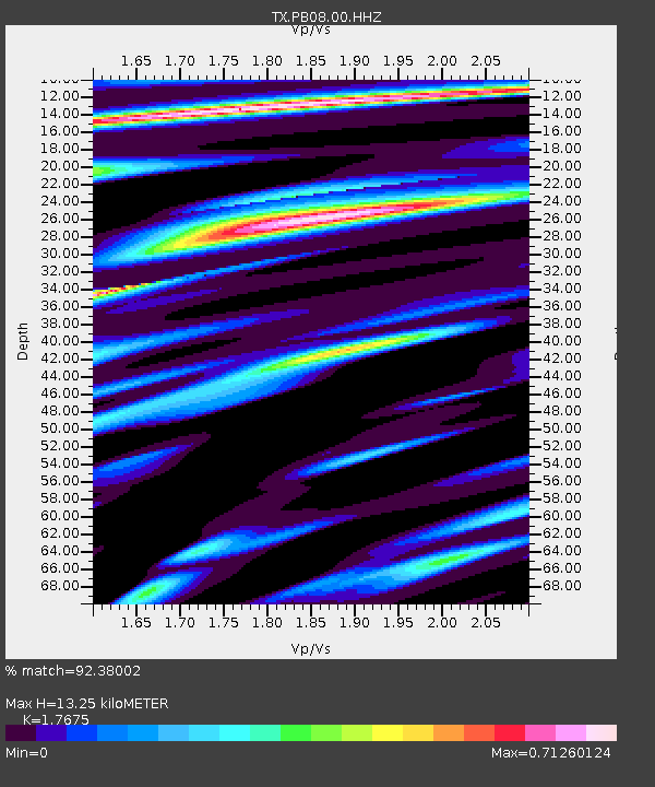
| Estimated Moho Depth: |
13.25 km |
| Estimated Crust Vp/Vs: |
1.77 |
| Assumed Crust Vp: |
6.121 km/s |
| Estimated Crust Vs: |
3.463 km/s |
| Estimated Crust Poisson's Ratio: |
0.26 |
|
| Radial Match: |
92.38002 % |
| Radial Bump: |
400 |
| Transverse Match: |
87.050156 % |
| Transverse Bump: |
400 |
| SOD ConfigId: |
3313551 |
| Insert Time: |
2019-03-08 10:26:24.003 +0000 |
| GWidth: |
2.5 |
| Max Bumps: |
400 |
| Tol: |
0.001 |
|

Signal To Noise
| Channel | StoN | STA | LTA |
| TX:PB08:00:HHZ:20190222T10:24:22.939999Z | 25.786451 | 3.846579E-6 | 1.4917055E-7 |
| TX:PB08:00:HH1:20190222T10:24:22.939999Z | 4.615335 | 6.5138795E-7 | 1.4113557E-7 |
| TX:PB08:00:HH2:20190222T10:24:22.939999Z | 15.0397215 | 1.2759651E-6 | 8.483968E-8 |
| Arrivals |
| Ps | 1.8 SECOND |
| PpPs | 5.6 SECOND |
| PsPs/PpSs | 7.4 SECOND |


