You are here: Home > Network List > TA - USArray Transportable Network (new EarthScope stations) Stations List
> Station 109C Camp Elliot, Mirimar, CA, USA > Earthquake Result Viewer
109C Camp Elliot, Mirimar, CA, USA - Earthquake Result Viewer
| Earthquake location: |
Vanuatu Islands |
| Earthquake latitude/longitude: |
-17.5/168.1 |
| Earthquake time(UTC): |
2010/08/10 (222) 05:23:44 GMT |
| Earthquake Depth: |
25 km |
| Earthquake Magnitude: |
6.4 MB, 7.3 MS, 7.3 MW, 7.2 MW |
| Earthquake Catalog/Contributor: |
WHDF/NEIC |
|
| Network: |
TA USArray Transportable Network (new EarthScope stations) |
| Station: |
109C Camp Elliot, Mirimar, CA, USA |
| Lat/Lon: |
32.89 N/117.11 W |
| Elevation: |
150 m |
|
| Distance: |
87.2 deg |
| Az: |
54.389 deg |
| Baz: |
247.204 deg |
| Ray Param: |
0.04344167 |
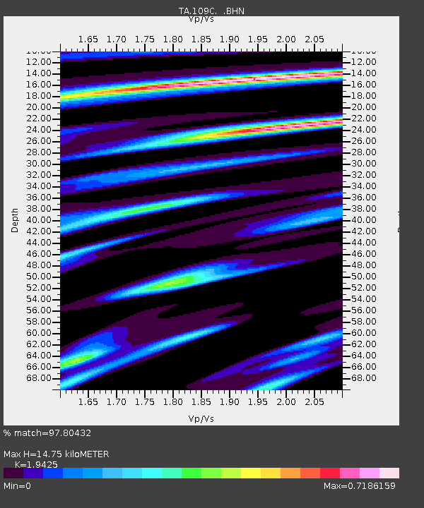
| Estimated Moho Depth: |
14.75 km |
| Estimated Crust Vp/Vs: |
1.94 |
| Assumed Crust Vp: |
6.264 km/s |
| Estimated Crust Vs: |
3.225 km/s |
| Estimated Crust Poisson's Ratio: |
0.32 |
|
| Radial Match: |
97.80432 % |
| Radial Bump: |
334 |
| Transverse Match: |
84.897156 % |
| Transverse Bump: |
400 |
| SOD ConfigId: |
319893 |
| Insert Time: |
2011-01-05 19:26:36.686 +0000 |
| GWidth: |
2.5 |
| Max Bumps: |
400 |
| Tol: |
0.001 |
|

Signal To Noise
| Channel | StoN | STA | LTA |
| TA:109C: :BHZ:20100810T05:35:57.745015Z | 22.252426 | 3.0342576E-6 | 1.3635626E-7 |
| TA:109C: :BHN:20100810T05:35:57.745015Z | 3.747024 | 4.1240793E-7 | 1.1006279E-7 |
| TA:109C: :BHE:20100810T05:35:57.745015Z | 10.162956 | 9.711999E-7 | 9.556274E-8 |
| Arrivals |
| Ps | 2.3 SECOND |
| PpPs | 6.8 SECOND |
| PsPs/PpSs | 9.1 SECOND |


