You are here: Home > Network List > TA - USArray Transportable Network (new EarthScope stations) Stations List
> Station H20A Greybull, WY, USA > Earthquake Result Viewer
H20A Greybull, WY, USA - Earthquake Result Viewer
| Earthquake location: |
Vanuatu Islands |
| Earthquake latitude/longitude: |
-17.5/168.1 |
| Earthquake time(UTC): |
2010/08/10 (222) 05:23:44 GMT |
| Earthquake Depth: |
25 km |
| Earthquake Magnitude: |
6.4 MB, 7.3 MS, 7.3 MW, 7.2 MW |
| Earthquake Catalog/Contributor: |
WHDF/NEIC |
|
| Network: |
TA USArray Transportable Network (new EarthScope stations) |
| Station: |
H20A Greybull, WY, USA |
| Lat/Lon: |
44.49 N/108.00 W |
| Elevation: |
1236 m |
|
| Distance: |
97.9 deg |
| Az: |
45.933 deg |
| Baz: |
253.289 deg |
| Ray Param: |
0.04006992 |
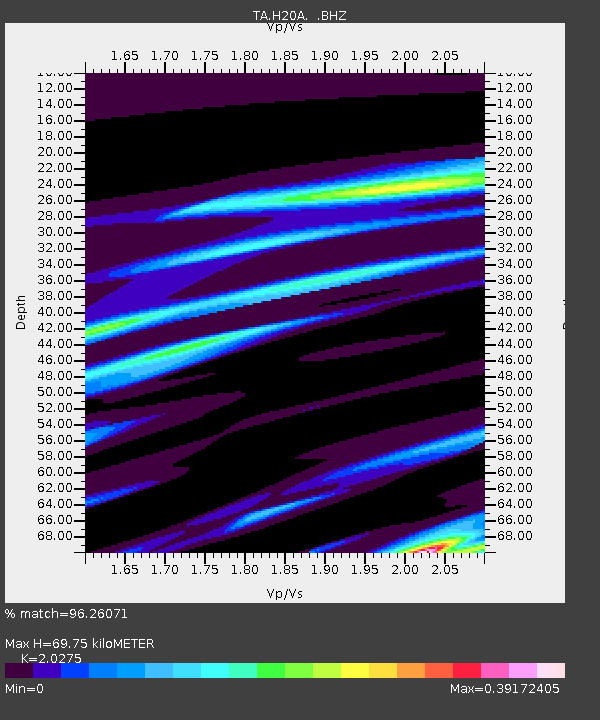
| Estimated Moho Depth: |
69.75 km |
| Estimated Crust Vp/Vs: |
2.03 |
| Assumed Crust Vp: |
6.178 km/s |
| Estimated Crust Vs: |
3.047 km/s |
| Estimated Crust Poisson's Ratio: |
0.34 |
|
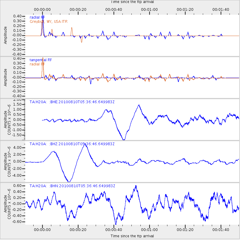
| Radial Match: |
96.26071 % |
| Radial Bump: |
400 |
| Transverse Match: |
85.3723 % |
| Transverse Bump: |
400 |
| SOD ConfigId: |
319893 |
| Insert Time: |
2011-01-05 19:27:52.474 +0000 |
| GWidth: |
2.5 |
| Max Bumps: |
400 |
| Tol: |
0.001 |
|
Signal To Noise
| Channel | StoN | STA | LTA |
| TA:H20A: :BHZ:20100810T05:36:46.649983Z | 22.111105 | 1.2646644E-6 | 5.7195898E-8 |
| TA:H20A: :BHN:20100810T05:36:46.649983Z | 1.9650612 | 1.2717071E-7 | 6.4715906E-8 |
| TA:H20A: :BHE:20100810T05:36:46.649983Z | 5.1259313 | 3.7871868E-7 | 7.388291E-8 |
| Arrivals |
| Ps | 12 SECOND |
| PpPs | 34 SECOND |
| PsPs/PpSs | 45 SECOND |


