You are here: Home > Network List > TA - USArray Transportable Network (new EarthScope stations) Stations List
> Station J21A Lysite, WY, USA > Earthquake Result Viewer
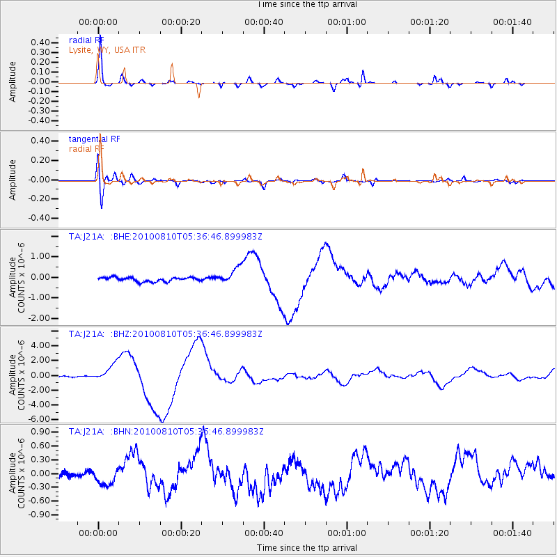
J21A Lysite, WY, USA - Earthquake Result Viewer
*The percent match for this event was below the threshold and hence no stack was calculated.
| Earthquake location: |
Vanuatu Islands |
| Earthquake latitude/longitude: |
-17.5/168.1 |
| Earthquake time(UTC): |
2010/08/10 (222) 05:23:44 GMT |
| Earthquake Depth: |
25 km |
| Earthquake Magnitude: |
6.4 MB, 7.3 MS, 7.3 MW, 7.2 MW |
| Earthquake Catalog/Contributor: |
WHDF/NEIC |
|
| Network: |
TA USArray Transportable Network (new EarthScope stations) |
| Station: |
J21A Lysite, WY, USA |
| Lat/Lon: |
43.35 N/107.45 W |
| Elevation: |
1913 m |
|
| Distance: |
97.9 deg |
| Az: |
47.152 deg |
| Baz: |
253.503 deg |
| Ray Param: |
$rayparam |
*The percent match for this event was below the threshold and hence was not used in the summary stack. |
|
| Radial Match: |
97.17627 % |
| Radial Bump: |
320 |
| Transverse Match: |
74.0807 % |
| Transverse Bump: |
400 |
| SOD ConfigId: |
319893 |
| Insert Time: |
2011-01-05 19:28:04.804 +0000 |
| GWidth: |
2.5 |
| Max Bumps: |
400 |
| Tol: |
0.001 |
|
Signal To Noise
| Channel | StoN | STA | LTA |
| TA:J21A: :BHZ:20100810T05:36:46.899983Z | 18.17495 | 1.2083486E-6 | 6.648429E-8 |
| TA:J21A: :BHN:20100810T05:36:46.899983Z | 1.5917673 | 1.883854E-7 | 1.1834984E-7 |
| TA:J21A: :BHE:20100810T05:36:46.899983Z | 4.2627983 | 4.2703462E-7 | 1.0017707E-7 |
| Arrivals |
| Ps | |
| PpPs | |
| PsPs/PpSs | |


