You are here: Home > Network List > AV - Alaska Volcano Observatory Stations List
> Station SPCL Chakachamna Lake, Mount Spurr, Alaska > Earthquake Result Viewer
SPCL Chakachamna Lake, Mount Spurr, Alaska - Earthquake Result Viewer
| Earthquake location: |
Mariana Islands |
| Earthquake latitude/longitude: |
20.2/145.5 |
| Earthquake time(UTC): |
2023/11/24 (328) 09:05:03 GMT |
| Earthquake Depth: |
16 km |
| Earthquake Magnitude: |
6.9 mww |
| Earthquake Catalog/Contributor: |
NEIC PDE/us |
|
| Network: |
AV Alaska Volcano Observatory |
| Station: |
SPCL Chakachamna Lake, Mount Spurr, Alaska |
| Lat/Lon: |
61.20 N/152.34 W |
| Elevation: |
1274 m |
|
| Distance: |
59.2 deg |
| Az: |
29.902 deg |
| Baz: |
255.253 deg |
| Ray Param: |
0.062358025 |
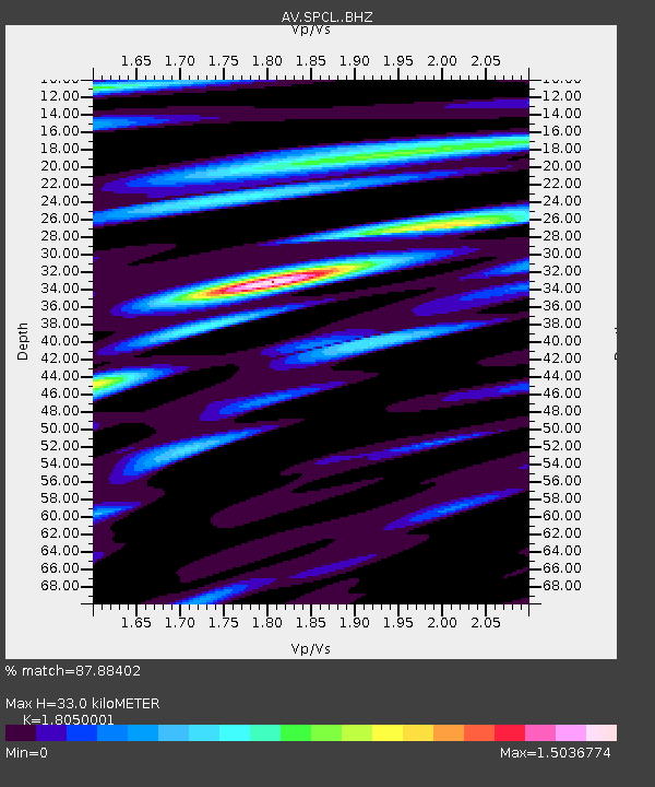
| Estimated Moho Depth: |
33.0 km |
| Estimated Crust Vp/Vs: |
1.81 |
| Assumed Crust Vp: |
6.566 km/s |
| Estimated Crust Vs: |
3.638 km/s |
| Estimated Crust Poisson's Ratio: |
0.28 |
|
| Radial Match: |
87.88402 % |
| Radial Bump: |
400 |
| Transverse Match: |
84.84371 % |
| Transverse Bump: |
400 |
| SOD ConfigId: |
33182351 |
| Insert Time: |
2023-12-08 09:13:30.764 +0000 |
| GWidth: |
2.5 |
| Max Bumps: |
400 |
| Tol: |
0.001 |
|

Signal To Noise
| Channel | StoN | STA | LTA |
| AV:SPCL: :BHZ:20231124T09:14:32.040014Z | 3.3809607 | 1.1843E-6 | 3.5028506E-7 |
| AV:SPCL: :BHN:20231124T09:14:32.040014Z | 0.92551315 | 3.747343E-7 | 4.0489354E-7 |
| AV:SPCL: :BHE:20231124T09:14:32.040014Z | 0.8244853 | 4.0467805E-7 | 4.90825E-7 |
| Arrivals |
| Ps | 4.2 SECOND |
| PpPs | 13 SECOND |
| PsPs/PpSs | 18 SECOND |


