You are here: Home > Network List > AV - Alaska Volcano Observatory Stations List
> Station SPU Mount Spurr, Mount Spurr, Alaska > Earthquake Result Viewer
SPU Mount Spurr, Mount Spurr, Alaska - Earthquake Result Viewer
| Earthquake location: |
Mariana Islands |
| Earthquake latitude/longitude: |
20.2/145.5 |
| Earthquake time(UTC): |
2023/11/24 (328) 09:05:03 GMT |
| Earthquake Depth: |
16 km |
| Earthquake Magnitude: |
6.9 mww |
| Earthquake Catalog/Contributor: |
NEIC PDE/us |
|
| Network: |
AV Alaska Volcano Observatory |
| Station: |
SPU Mount Spurr, Mount Spurr, Alaska |
| Lat/Lon: |
61.18 N/152.06 W |
| Elevation: |
800 m |
|
| Distance: |
59.3 deg |
| Az: |
29.959 deg |
| Baz: |
255.53 deg |
| Ray Param: |
0.06227256 |
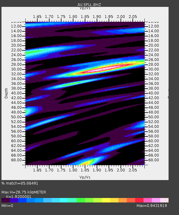
| Estimated Moho Depth: |
29.75 km |
| Estimated Crust Vp/Vs: |
1.92 |
| Assumed Crust Vp: |
6.566 km/s |
| Estimated Crust Vs: |
3.42 km/s |
| Estimated Crust Poisson's Ratio: |
0.31 |
|
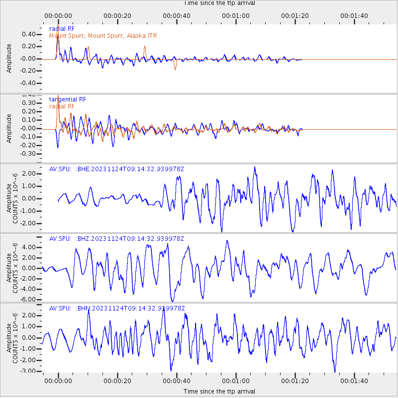
| Radial Match: |
85.86491 % |
| Radial Bump: |
400 |
| Transverse Match: |
69.24684 % |
| Transverse Bump: |
400 |
| SOD ConfigId: |
33182351 |
| Insert Time: |
2023-12-08 09:13:34.742 +0000 |
| GWidth: |
2.5 |
| Max Bumps: |
400 |
| Tol: |
0.001 |
|
Signal To Noise
| Channel | StoN | STA | LTA |
| AV:SPU: :BHZ:20231124T09:14:32.939978Z | 4.645731 | 1.3490676E-6 | 2.9038867E-7 |
| AV:SPU: :BHN:20231124T09:14:32.939978Z | 1.6908193 | 7.125668E-7 | 4.214329E-7 |
| AV:SPU: :BHE:20231124T09:14:32.939978Z | 1.2403553 | 3.8469318E-7 | 3.1014758E-7 |
| Arrivals |
| Ps | 4.4 SECOND |
| PpPs | 13 SECOND |
| PsPs/PpSs | 17 SECOND |


