You are here: Home > Network List > CC - Cascade Chain Volcano Monitoring Stations List
> Station TABR Tahoma Bridge > Earthquake Result Viewer
TABR Tahoma Bridge - Earthquake Result Viewer
| Earthquake location: |
Mariana Islands |
| Earthquake latitude/longitude: |
20.2/145.5 |
| Earthquake time(UTC): |
2023/11/24 (328) 09:05:03 GMT |
| Earthquake Depth: |
16 km |
| Earthquake Magnitude: |
6.9 mww |
| Earthquake Catalog/Contributor: |
NEIC PDE/us |
|
| Network: |
CC Cascade Chain Volcano Monitoring |
| Station: |
TABR Tahoma Bridge |
| Lat/Lon: |
46.80 N/121.85 W |
| Elevation: |
1278 m |
|
| Distance: |
77.3 deg |
| Az: |
44.701 deg |
| Baz: |
285.841 deg |
| Ray Param: |
0.050397966 |
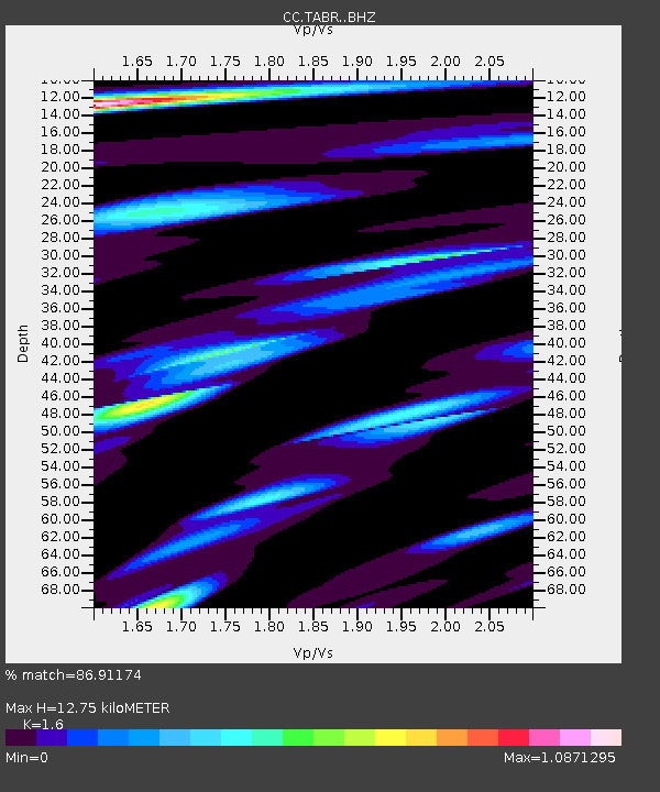
| Estimated Moho Depth: |
12.75 km |
| Estimated Crust Vp/Vs: |
1.60 |
| Assumed Crust Vp: |
6.597 km/s |
| Estimated Crust Vs: |
4.123 km/s |
| Estimated Crust Poisson's Ratio: |
0.18 |
|
| Radial Match: |
86.91174 % |
| Radial Bump: |
400 |
| Transverse Match: |
79.71597 % |
| Transverse Bump: |
400 |
| SOD ConfigId: |
33182351 |
| Insert Time: |
2023-12-08 09:15:52.591 +0000 |
| GWidth: |
2.5 |
| Max Bumps: |
400 |
| Tol: |
0.001 |
|

Signal To Noise
| Channel | StoN | STA | LTA |
| CC:TABR: :BHZ:20231124T09:16:25.459997Z | 2.98328 | 5.0069673E-7 | 1.6783432E-7 |
| CC:TABR: :BHN:20231124T09:16:25.459997Z | 0.4885031 | 1.5611666E-7 | 3.1958172E-7 |
| CC:TABR: :BHE:20231124T09:16:25.459997Z | 0.36696866 | 1.3308465E-7 | 3.6265945E-7 |
| Arrivals |
| Ps | 1.2 SECOND |
| PpPs | 4.8 SECOND |
| PsPs/PpSs | 6.0 SECOND |


