You are here: Home > Network List > SC - New Mexico Tech Seismic Network Stations List
> Station GDL2 Guadalupe Mountains, New Mexico > Earthquake Result Viewer
GDL2 Guadalupe Mountains, New Mexico - Earthquake Result Viewer
| Earthquake location: |
Mariana Islands |
| Earthquake latitude/longitude: |
20.2/145.5 |
| Earthquake time(UTC): |
2023/11/24 (328) 09:05:03 GMT |
| Earthquake Depth: |
16 km |
| Earthquake Magnitude: |
6.9 mww |
| Earthquake Catalog/Contributor: |
NEIC PDE/us |
|
| Network: |
SC New Mexico Tech Seismic Network |
| Station: |
GDL2 Guadalupe Mountains, New Mexico |
| Lat/Lon: |
32.20 N/104.36 W |
| Elevation: |
1211 m |
|
| Distance: |
95.3 deg |
| Az: |
53.093 deg |
| Baz: |
297.613 deg |
| Ray Param: |
0.040833198 |
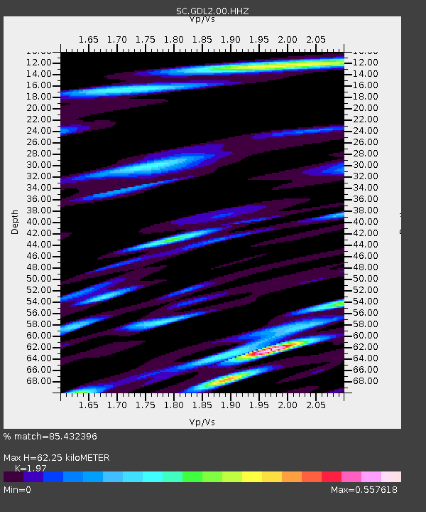
| Estimated Moho Depth: |
62.25 km |
| Estimated Crust Vp/Vs: |
1.97 |
| Assumed Crust Vp: |
6.232 km/s |
| Estimated Crust Vs: |
3.163 km/s |
| Estimated Crust Poisson's Ratio: |
0.33 |
|
| Radial Match: |
85.432396 % |
| Radial Bump: |
400 |
| Transverse Match: |
77.49721 % |
| Transverse Bump: |
383 |
| SOD ConfigId: |
33182351 |
| Insert Time: |
2023-12-08 09:27:12.929 +0000 |
| GWidth: |
2.5 |
| Max Bumps: |
400 |
| Tol: |
0.001 |
|

Signal To Noise
| Channel | StoN | STA | LTA |
| SC:GDL2:00:HHZ:20231124T09:17:54.405004Z | 1.2006958 | 1.3391523E-8 | 1.1153135E-8 |
| SC:GDL2:00:HHN:20231124T09:17:54.405004Z | 0.99158275 | 8.742493E-9 | 8.816706E-9 |
| SC:GDL2:00:HHE:20231124T09:17:54.405004Z | 2.1181567 | 1.15159144E-8 | 5.436762E-9 |
| Arrivals |
| Ps | 9.9 SECOND |
| PpPs | 29 SECOND |
| PsPs/PpSs | 39 SECOND |


