You are here: Home > Network List > UU - University of Utah Regional Network Stations List
> Station FPU Francis Peak, UT, USA > Earthquake Result Viewer
FPU Francis Peak, UT, USA - Earthquake Result Viewer
| Earthquake location: |
Mariana Islands |
| Earthquake latitude/longitude: |
20.2/145.5 |
| Earthquake time(UTC): |
2023/11/24 (328) 09:05:03 GMT |
| Earthquake Depth: |
16 km |
| Earthquake Magnitude: |
6.9 mww |
| Earthquake Catalog/Contributor: |
NEIC PDE/us |
|
| Network: |
UU University of Utah Regional Network |
| Station: |
FPU Francis Peak, UT, USA |
| Lat/Lon: |
41.03 N/111.84 W |
| Elevation: |
2816 m |
|
| Distance: |
86.1 deg |
| Az: |
47.738 deg |
| Baz: |
293.22 deg |
| Ray Param: |
0.044317853 |
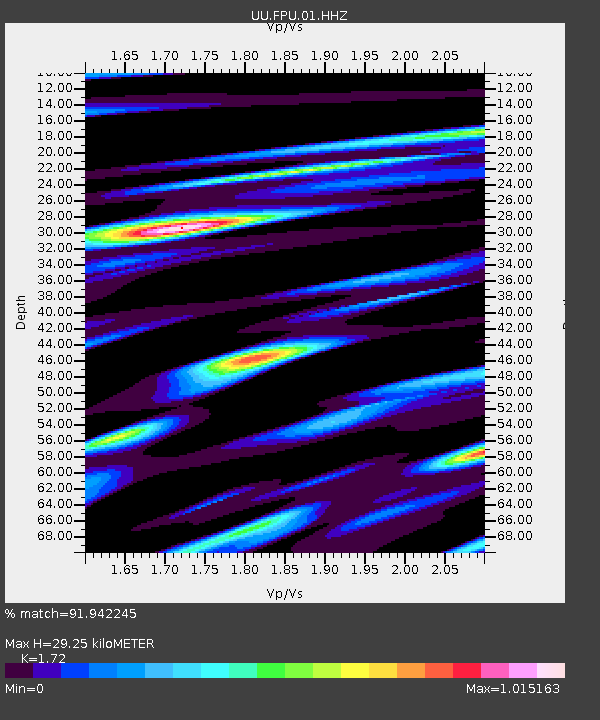
| Estimated Moho Depth: |
29.25 km |
| Estimated Crust Vp/Vs: |
1.72 |
| Assumed Crust Vp: |
6.155 km/s |
| Estimated Crust Vs: |
3.578 km/s |
| Estimated Crust Poisson's Ratio: |
0.24 |
|
| Radial Match: |
91.942245 % |
| Radial Bump: |
400 |
| Transverse Match: |
81.38509 % |
| Transverse Bump: |
400 |
| SOD ConfigId: |
33182351 |
| Insert Time: |
2023-12-08 09:30:32.197 +0000 |
| GWidth: |
2.5 |
| Max Bumps: |
400 |
| Tol: |
0.001 |
|

Signal To Noise
| Channel | StoN | STA | LTA |
| UU:FPU:01:HHZ:20231124T09:17:11.420019Z | 3.2038338 | 7.210108E-7 | 2.2504626E-7 |
| UU:FPU:01:HHN:20231124T09:17:11.420019Z | 1.3732105 | 4.6144743E-7 | 3.3603544E-7 |
| UU:FPU:01:HHE:20231124T09:17:11.420019Z | 1.8405018 | 2.8584287E-7 | 1.5530703E-7 |
| Arrivals |
| Ps | 3.5 SECOND |
| PpPs | 13 SECOND |
| PsPs/PpSs | 16 SECOND |


