You are here: Home > Network List > UW - Pacific Northwest Regional Seismic Network Stations List
> Station COUGS Pullman, WA, USA > Earthquake Result Viewer
COUGS Pullman, WA, USA - Earthquake Result Viewer
| Earthquake location: |
Mariana Islands |
| Earthquake latitude/longitude: |
20.2/145.5 |
| Earthquake time(UTC): |
2023/11/24 (328) 09:05:03 GMT |
| Earthquake Depth: |
16 km |
| Earthquake Magnitude: |
6.9 mww |
| Earthquake Catalog/Contributor: |
NEIC PDE/us |
|
| Network: |
UW Pacific Northwest Regional Seismic Network |
| Station: |
COUGS Pullman, WA, USA |
| Lat/Lon: |
46.73 N/117.13 W |
| Elevation: |
776 m |
|
| Distance: |
80.4 deg |
| Az: |
43.782 deg |
| Baz: |
289.089 deg |
| Ray Param: |
0.04827641 |
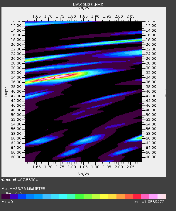
| Estimated Moho Depth: |
33.75 km |
| Estimated Crust Vp/Vs: |
1.73 |
| Assumed Crust Vp: |
6.571 km/s |
| Estimated Crust Vs: |
3.809 km/s |
| Estimated Crust Poisson's Ratio: |
0.25 |
|
| Radial Match: |
87.55384 % |
| Radial Bump: |
364 |
| Transverse Match: |
74.771645 % |
| Transverse Bump: |
400 |
| SOD ConfigId: |
33182351 |
| Insert Time: |
2023-12-08 09:30:55.379 +0000 |
| GWidth: |
2.5 |
| Max Bumps: |
400 |
| Tol: |
0.001 |
|

Signal To Noise
| Channel | StoN | STA | LTA |
| UW:COUGS: :HHZ:20231124T09:16:42.490026Z | 3.2284932 | 8.8283167E-7 | 2.7345004E-7 |
| UW:COUGS: :HHN:20231124T09:16:42.490026Z | 1.1731108 | 3.2302987E-7 | 2.7536177E-7 |
| UW:COUGS: :HHE:20231124T09:16:42.490026Z | 1.0371283 | 3.1005501E-7 | 2.989553E-7 |
| Arrivals |
| Ps | 3.8 SECOND |
| PpPs | 14 SECOND |
| PsPs/PpSs | 17 SECOND |


