You are here: Home > Network List > WW - Idaho Seismic Network () Stations List
> Station BILL Emerald Creek, Idaho > Earthquake Result Viewer
BILL Emerald Creek, Idaho - Earthquake Result Viewer
| Earthquake location: |
Mariana Islands |
| Earthquake latitude/longitude: |
20.2/145.5 |
| Earthquake time(UTC): |
2023/11/24 (328) 09:05:03 GMT |
| Earthquake Depth: |
16 km |
| Earthquake Magnitude: |
6.9 mww |
| Earthquake Catalog/Contributor: |
NEIC PDE/us |
|
| Network: |
WW Idaho Seismic Network () |
| Station: |
BILL Emerald Creek, Idaho |
| Lat/Lon: |
47.03 N/116.34 W |
| Elevation: |
866 m |
|
| Distance: |
80.8 deg |
| Az: |
43.308 deg |
| Baz: |
289.592 deg |
| Ray Param: |
0.047993865 |
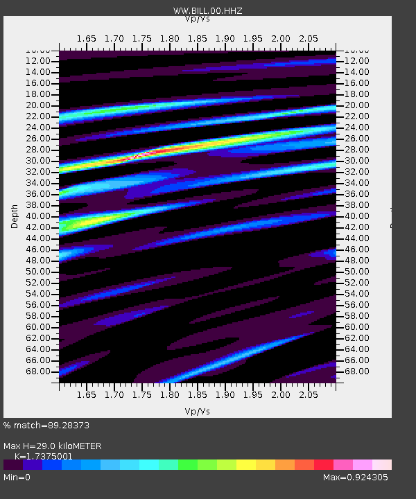
| Estimated Moho Depth: |
29.0 km |
| Estimated Crust Vp/Vs: |
1.74 |
| Assumed Crust Vp: |
6.571 km/s |
| Estimated Crust Vs: |
3.782 km/s |
| Estimated Crust Poisson's Ratio: |
0.25 |
|
| Radial Match: |
89.28373 % |
| Radial Bump: |
400 |
| Transverse Match: |
80.10174 % |
| Transverse Bump: |
400 |
| SOD ConfigId: |
33182351 |
| Insert Time: |
2023-12-08 09:33:05.532 +0000 |
| GWidth: |
2.5 |
| Max Bumps: |
400 |
| Tol: |
0.001 |
|
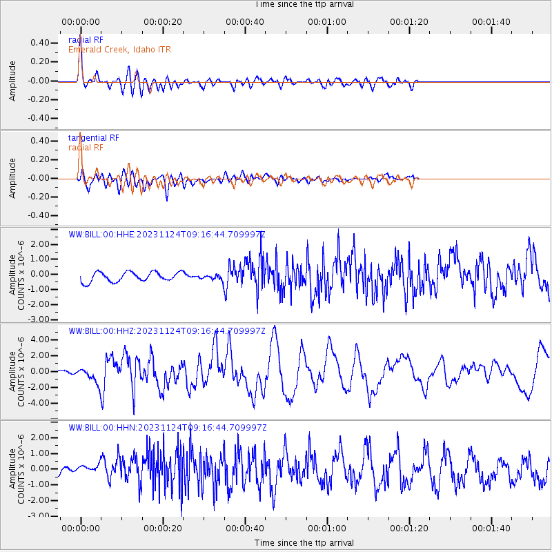
Signal To Noise
| Channel | StoN | STA | LTA |
| WW:BILL:00:HHZ:20231124T09:16:44.709997Z | 3.8111603 | 9.698379E-7 | 2.5447312E-7 |
| WW:BILL:00:HHN:20231124T09:16:44.709997Z | 2.1712837 | 5.661034E-7 | 2.607229E-7 |
| WW:BILL:00:HHE:20231124T09:16:44.709997Z | 0.49718338 | 1.5733183E-7 | 3.164463E-7 |
| Arrivals |
| Ps | 3.4 SECOND |
| PpPs | 12 SECOND |
| PsPs/PpSs | 15 SECOND |


