You are here: Home > Network List > US - United States National Seismic Network Stations List
> Station LONY Lake Ozonia, New York, USA > Earthquake Result Viewer
LONY Lake Ozonia, New York, USA - Earthquake Result Viewer
| Earthquake location: |
Peru-Ecuador Border Region |
| Earthquake latitude/longitude: |
-2.2/-77.0 |
| Earthquake time(UTC): |
2019/02/22 (053) 10:17:22 GMT |
| Earthquake Depth: |
132 km |
| Earthquake Magnitude: |
7.5 mww |
| Earthquake Catalog/Contributor: |
NEIC PDE/us |
|
| Network: |
US United States National Seismic Network |
| Station: |
LONY Lake Ozonia, New York, USA |
| Lat/Lon: |
44.62 N/74.58 W |
| Elevation: |
440 m |
|
| Distance: |
46.7 deg |
| Az: |
2.396 deg |
| Baz: |
183.353 deg |
| Ray Param: |
0.070022024 |
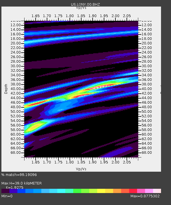
| Estimated Moho Depth: |
39.0 km |
| Estimated Crust Vp/Vs: |
1.93 |
| Assumed Crust Vp: |
6.419 km/s |
| Estimated Crust Vs: |
3.33 km/s |
| Estimated Crust Poisson's Ratio: |
0.32 |
|
| Radial Match: |
99.19096 % |
| Radial Bump: |
176 |
| Transverse Match: |
97.93822 % |
| Transverse Bump: |
379 |
| SOD ConfigId: |
3313551 |
| Insert Time: |
2019-03-08 10:28:03.033 +0000 |
| GWidth: |
2.5 |
| Max Bumps: |
400 |
| Tol: |
0.001 |
|
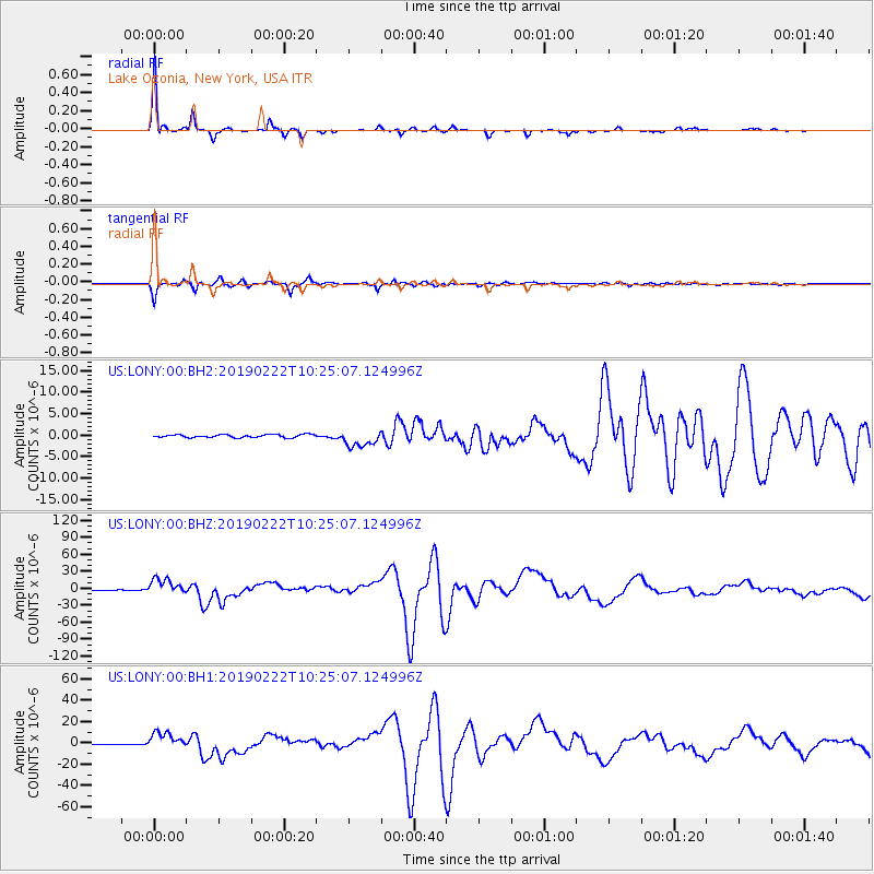
Signal To Noise
| Channel | StoN | STA | LTA |
| US:LONY:00:BHZ:20190222T10:25:07.124996Z | 30.341604 | 1.3852617E-5 | 4.5655517E-7 |
| US:LONY:00:BH1:20190222T10:25:07.124996Z | 19.125294 | 7.986259E-6 | 4.175758E-7 |
| US:LONY:00:BH2:20190222T10:25:07.124996Z | 5.850832 | 2.0092436E-6 | 3.4341164E-7 |
| Arrivals |
| Ps | 6.0 SECOND |
| PpPs | 17 SECOND |
| PsPs/PpSs | 23 SECOND |


