You are here: Home > Network List > UW - Pacific Northwest Regional Seismic Network Stations List
> Station FORK Quillayute Airport, Forks, WA > Earthquake Result Viewer
FORK Quillayute Airport, Forks, WA - Earthquake Result Viewer
| Earthquake location: |
Vanuatu Islands |
| Earthquake latitude/longitude: |
-17.5/168.1 |
| Earthquake time(UTC): |
2010/08/10 (222) 05:23:44 GMT |
| Earthquake Depth: |
25 km |
| Earthquake Magnitude: |
6.4 MB, 7.3 MS, 7.3 MW, 7.2 MW |
| Earthquake Catalog/Contributor: |
WHDF/NEIC |
|
| Network: |
UW Pacific Northwest Regional Seismic Network |
| Station: |
FORK Quillayute Airport, Forks, WA |
| Lat/Lon: |
47.95 N/124.57 W |
| Elevation: |
48 m |
|
| Distance: |
88.6 deg |
| Az: |
38.367 deg |
| Baz: |
241.747 deg |
| Ray Param: |
0.042467862 |
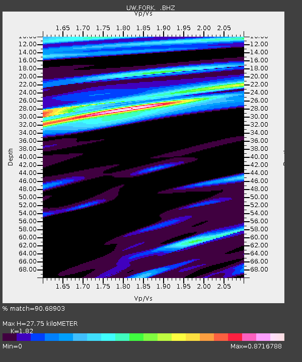
| Estimated Moho Depth: |
27.75 km |
| Estimated Crust Vp/Vs: |
1.82 |
| Assumed Crust Vp: |
6.134 km/s |
| Estimated Crust Vs: |
3.37 km/s |
| Estimated Crust Poisson's Ratio: |
0.28 |
|
| Radial Match: |
90.68903 % |
| Radial Bump: |
400 |
| Transverse Match: |
82.838974 % |
| Transverse Bump: |
400 |
| SOD ConfigId: |
319893 |
| Insert Time: |
2011-01-05 19:33:37.762 +0000 |
| GWidth: |
2.5 |
| Max Bumps: |
400 |
| Tol: |
0.001 |
|

Signal To Noise
| Channel | StoN | STA | LTA |
| UW:FORK: :BHZ:20100810T05:36:04.050007Z | 5.6825323 | 3.6033973E-6 | 6.3411824E-7 |
| UW:FORK: :BHN:20100810T05:36:04.050007Z | 0.88933885 | 5.4995115E-7 | 6.18382E-7 |
| UW:FORK: :BHE:20100810T05:36:04.050007Z | 0.9207663 | 7.4800033E-7 | 8.123672E-7 |
| Arrivals |
| Ps | 3.8 SECOND |
| PpPs | 13 SECOND |
| PsPs/PpSs | 16 SECOND |


