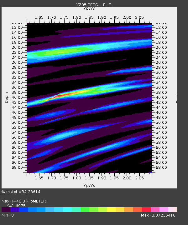
BERG Bagley Icefield - Earthquake Result Viewer

Earthquake location: Vanuatu Islands
Earthquake latitude/longitude: -17.5/168.1
Earthquake time(UTC): 2010/08/10 (222) 05:23:44 GMT
Earthquake Depth: 25 km
Earthquake Magnitude: 6.4 MB, 7.3 MS, 7.3 MW, 7.2 MW
Earthquake Catalog/Contributor: WHDF/NEIC
Network: XZ STEEP: St. Elias Erosion and Tectonics Project
Station: BERG Bagley Icefield
Lat/Lon: 60.39 N/143.70 W
Elevation: 474 m
Distance: 86.8 deg
Az: 21.773 deg
Baz: 225.453 deg
Ray Param: 0.04375089
Estimated Moho Depth: 40.0 km
Estimated Crust Vp/Vs: 1.70
Assumed Crust Vp: 6.566 km/s
Estimated Crust Vs: 3.868 km/s
Estimated Crust Poisson's Ratio: 0.23
Radial Match: 94.33614 %
Radial Bump: 400
Transverse Match: 78.09196 %
Transverse Bump: 400
SOD ConfigId: 319893
Insert Time: 2011-01-05 19:34:11.026 +0000
GWidth: 2.5
Max Bumps: 400
Tol: 0.001

Signal To Noise

ChannelStoNSTALTA
XZ:BERG: :BHZ:20100810T05:35:55.688008Z14.1062544.0920663E-62.900888E-7
XZ:BERG: :BHN:20100810T05:35:55.688008Z3.00526981.2454813E-64.1443244E-7
XZ:BERG: :BHE:20100810T05:35:55.688008Z2.38369921.088933E-64.5682484E-7
Arrivals
Ps4.4 SECOND
PpPs16 SECOND
PsPs/PpSs20 SECOND