You are here: Home > Network List > AZ - ANZA Regional Network Stations List
> Station BZN AZ.BZN > Earthquake Result Viewer
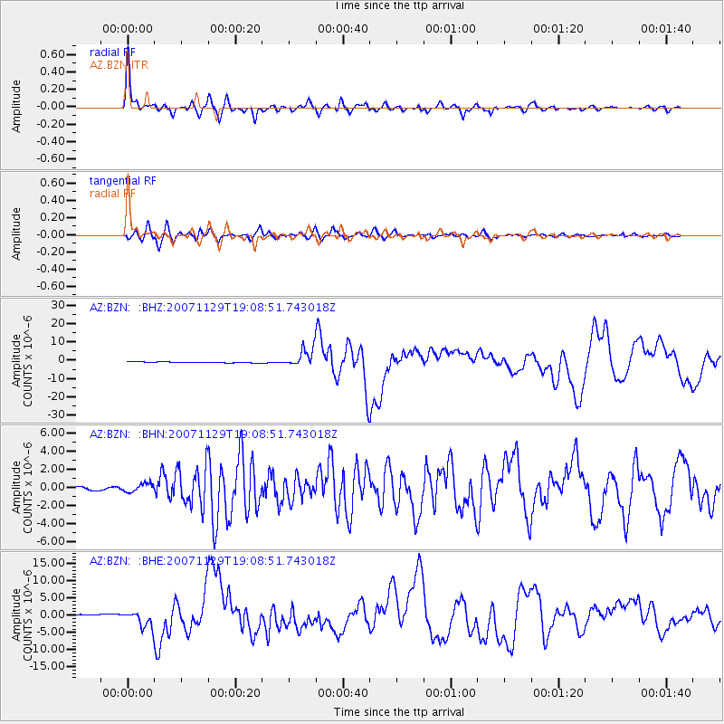
BZN AZ.BZN - Earthquake Result Viewer

| Earthquake location: |
Windward Islands |
| Earthquake latitude/longitude: |
15.0/-61.3 |
| Earthquake time(UTC): |
2007/11/29 (333) 19:00:19 GMT |
| Earthquake Depth: |
148 km |
| Earthquake Magnitude: |
6.9 MB, 7.4 MW, 7.4 MW |
| Earthquake Catalog/Contributor: |
WHDF/NEIC |
|
| Network: |
AZ ANZA Regional Network |
| Station: |
BZN AZ.BZN |
| Lat/Lon: |
33.49 N/116.67 W |
| Elevation: |
1301 m |
|
| Distance: |
53.2 deg |
| Az: |
300.734 deg |
| Baz: |
96.229 deg |
| Ray Param: |
0.0657797 |
| Estimated Moho Depth: |
46.5 km |
| Estimated Crust Vp/Vs: |
1.65 |
| Assumed Crust Vp: |
6.264 km/s |
| Estimated Crust Vs: |
3.79 km/s |
| Estimated Crust Poisson's Ratio: |
0.21 |
|
| Radial Match: |
96.31208 % |
| Radial Bump: |
359 |
| Transverse Match: |
88.28716 % |
| Transverse Bump: |
400 |
| SOD ConfigId: |
2564 |
| Insert Time: |
2010-02-26 18:44:05.333 +0000 |
| GWidth: |
2.5 |
| Max Bumps: |
400 |
| Tol: |
0.001 |
|
Signal To Noise
| Channel | StoN | STA | LTA |
| AZ:BZN: :BHN:20071129T19:08:51.743018Z | 3.1468036 | 4.609545E-7 | 1.4648342E-7 |
| AZ:BZN: :BHE:20071129T19:08:51.743018Z | 7.062911 | 2.418022E-6 | 3.4235487E-7 |
| AZ:BZN: :BHZ:20071129T19:08:51.743018Z | 18.722366 | 5.098245E-6 | 2.7230772E-7 |
| Arrivals |
| Ps | 5.1 SECOND |
| PpPs | 19 SECOND |
| PsPs/PpSs | 24 SECOND |


