You are here: Home > Network List > US - United States National Seismic Network Stations List
> Station TPNV Topopah Spring, Nevada, USA > Earthquake Result Viewer
TPNV Topopah Spring, Nevada, USA - Earthquake Result Viewer
| Earthquake location: |
Peru-Ecuador Border Region |
| Earthquake latitude/longitude: |
-2.2/-77.0 |
| Earthquake time(UTC): |
2019/02/22 (053) 10:17:22 GMT |
| Earthquake Depth: |
132 km |
| Earthquake Magnitude: |
7.5 mww |
| Earthquake Catalog/Contributor: |
NEIC PDE/us |
|
| Network: |
US United States National Seismic Network |
| Station: |
TPNV Topopah Spring, Nevada, USA |
| Lat/Lon: |
36.95 N/116.25 W |
| Elevation: |
1600 m |
|
| Distance: |
53.3 deg |
| Az: |
320.826 deg |
| Baz: |
128.007 deg |
| Ray Param: |
0.06573181 |
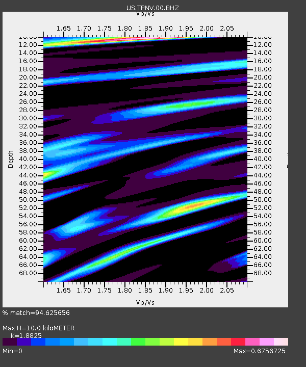
| Estimated Moho Depth: |
10.0 km |
| Estimated Crust Vp/Vs: |
1.88 |
| Assumed Crust Vp: |
6.279 km/s |
| Estimated Crust Vs: |
3.335 km/s |
| Estimated Crust Poisson's Ratio: |
0.30 |
|
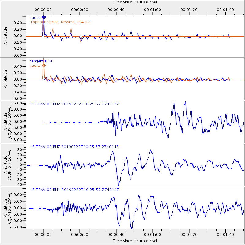
| Radial Match: |
94.625656 % |
| Radial Bump: |
400 |
| Transverse Match: |
87.174324 % |
| Transverse Bump: |
400 |
| SOD ConfigId: |
3313551 |
| Insert Time: |
2019-03-08 10:28:28.489 +0000 |
| GWidth: |
2.5 |
| Max Bumps: |
400 |
| Tol: |
0.001 |
|
Signal To Noise
| Channel | StoN | STA | LTA |
| US:TPNV:00:BHZ:20190222T10:25:57.274014Z | 15.862506 | 2.8000184E-6 | 1.7651803E-7 |
| US:TPNV:00:BH1:20190222T10:25:57.274014Z | 2.4192655 | 7.3282274E-7 | 3.0291127E-7 |
| US:TPNV:00:BH2:20190222T10:25:57.274014Z | 2.401022 | 7.259744E-7 | 3.0236058E-7 |
| Arrivals |
| Ps | 1.5 SECOND |
| PpPs | 4.4 SECOND |
| PsPs/PpSs | 5.9 SECOND |


