You are here: Home > Network List > AZ - ANZA Regional Network Stations List
> Station BZN AZ.BZN > Earthquake Result Viewer
BZN AZ.BZN - Earthquake Result Viewer

| Earthquake location: |
Peru-Ecuador Border Region |
| Earthquake latitude/longitude: |
-2.3/-77.8 |
| Earthquake time(UTC): |
2007/11/16 (320) 03:13:00 GMT |
| Earthquake Depth: |
123 km |
| Earthquake Magnitude: |
6.3 MB, 6.8 MW, 6.7 MW |
| Earthquake Catalog/Contributor: |
WHDF/NEIC |
|
| Network: |
AZ ANZA Regional Network |
| Station: |
BZN AZ.BZN |
| Lat/Lon: |
33.49 N/116.67 W |
| Elevation: |
1301 m |
|
| Distance: |
51.1 deg |
| Az: |
317.653 deg |
| Baz: |
126.348 deg |
| Ray Param: |
0.067248166 |
| Estimated Moho Depth: |
25.75 km |
| Estimated Crust Vp/Vs: |
1.78 |
| Assumed Crust Vp: |
6.264 km/s |
| Estimated Crust Vs: |
3.519 km/s |
| Estimated Crust Poisson's Ratio: |
0.27 |
|
| Radial Match: |
95.234886 % |
| Radial Bump: |
400 |
| Transverse Match: |
82.7297 % |
| Transverse Bump: |
400 |
| SOD ConfigId: |
2564 |
| Insert Time: |
2010-02-26 18:44:07.460 +0000 |
| GWidth: |
2.5 |
| Max Bumps: |
400 |
| Tol: |
0.001 |
|
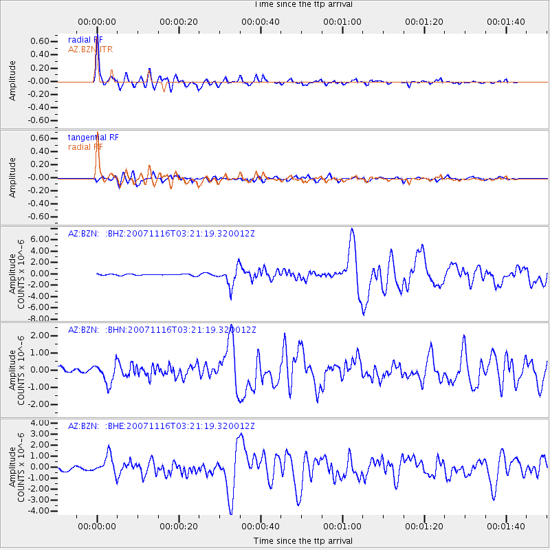
Signal To Noise
| Channel | StoN | STA | LTA |
| AZ:BZN: :BHN:20071116T03:21:19.320012Z | 4.379243 | 5.9268814E-7 | 1.3534031E-7 |
| AZ:BZN: :BHE:20071116T03:21:19.320012Z | 4.320081 | 8.8987684E-7 | 2.0598614E-7 |
| AZ:BZN: :BHZ:20071116T03:21:19.320012Z | 13.6396885 | 1.618238E-6 | 1.1864185E-7 |
| Arrivals |
| Ps | 3.4 SECOND |
| PpPs | 11 SECOND |
| PsPs/PpSs | 14 SECOND |


